East Gippsland
The East Gippsland natural region in the Flora of Victoria system (Conn 1993) comprises the Monaro Tablelands, Highlands-Far East, East Gippsland Uplands and East Gippsland Lowlands regions in the current system of bioregions.
Location
The north-western boundary of East Gippsland approximates the 1200-metre altitude contour and is shared with the Snowfields Region. The East Gippsland Region includes the area south of this boundary to the Victorian coast. The western boundary has been arbitrarily defined as the Tambo River valley and the Omeo Highway from near Mt Tongio to Tambo Crossing, then sweeping westward to include the gorge and environs of the Mitchell River, with the most westerly limit including the Mt Moornapa Flora Reserve (25 km NNE of Stratford). This boundary is shared by the Eastern Highlands south to Stockdale, from where there is a common boundary to the east with the Gippsland Plains. In New South Wales this region adjoins the Monaro Region (sensu Costin 1954) of the Southern Tablelands and is continuous with the South Coast Region. A small part of the Monaro Tableland extends into Victoria in the vicinity of Bendoc. In New South Wales the ‘East Gippsland’ Region is here defined as including the Callitris glaucophylla–Eucalyptus albens rainshadow woodland association, the E. melliodora–E. blakelyi woodland association, the E. macrorhyncha–E. rossii dry sclerophyll forest association, and the E. fastigata–E. viminalis wet sclerophyll forest association.
Major grids V, W and Z. Approximate area 12 820 km2.
Major landforms
Several major Devonian granitic massifs have intruded through the thick Ordovician sedimentary bedrock (Talent 1969). The granitic outcrops are generally granodiorites or granites. Examples of these outcrops include Mt Kaye, Gabo Island, Genoa Peak, Howe Range, Mt Ellery, Mt Raymond and Cape Conran (Anon. 1974a). The presence of large granitic tors are characteristic of these areas (e.g. summit area of Mt Ellery). Extensive sands and gravels, principally of non-marine origin, flank the southern part of the highlands. These non-marine sediments occur in the Cann, Combienbar, Bemm, and Genoa River valleys. Extensive Quaternary dune systems have developed along the coast, while large flats and swamps occur on the coastal plain and foothills of the ranges. Four major physiographic units are represented in the area.
-
The elevated tablelands are an extension of the Monaro Tablelands of New South Wales, and continue southwards onto the Errinundra Plateau and to a few other isolated areas. These tablelands are characterized by low relief with wide shallow valleys.
-
The dissected ridges cover most of the region. Here the topography is moderately sloping ridges in a complex pattern of dissection. Scattered through this zone are a number of small intermontane basins, such as Combienbar and Buldah, formed by downfaulting or differential erosion. Areas on Ordovician bedrock tend to be deeply dissected by numerous streams, whereas those on igneous rock tend to be more even, with a less well-developed drainage system.
-
The plains are mostly composed of Tertiary sediments, although other rock types are present. The plains are generally fairly flat, with incised valleys.
-
The coastal unit is confined almost entirely to Quaternary deposits along the coast. It consists mainly of sand dunes that have formed parallel to the prevailing winds, however, coastal swamps are also present on low-lying flat land (e.g. Ewings Marsh).
For further information regarding the formative processes and physiography of the region see Douglas (this volume) and Gibbons and Rowan (this volume).
Climate
The climate of the region is influenced by depressions off the New South Wales coast and incursions of warm, moist subtropical air from the Tasman Sea (Linforth 1969). East Gippsland receives most of its rainfall from depressions centred off the east coast of Australia. The climate is therefore more similar to that of coastal New South Wales than it is to other parts of Victoria. The southern, central and eastern parts of the region receive an annual average rainfall of between 800 and 1200 mm, with the Errinundra Plateau receiving up to 1400 mm or more. The south-western and north-western parts of the region are drier, with an annual average rainfall of 600–900 mm. Temperatures in the narrow coastal area are mild. Further inland, the minimum temperatures decrease and the maximum temperatures increase. See also ‘Climate of Victoria’ (this volume).
Vegetation
Coastal communities
Primary dune scrub
The coastal primary dune and sea-cliff communities consist of grasses, herbs and low shrubs. The species composition is consistent with that found elsewhere in coastal Victoria. The substrate is either calcareous sand or sedimentary rock. Characteristically, this association has low species diversity, with the most common species being Carpobrotus rossii, Leptospermum laevigatum and Ozothamnus turbinatus. Other common species include Acacia longifolia, Banksia integrifolia, Leucophyta brownii, Myoporum insulare and Senecio lautus. Examples of this community occur at Cape Conran and near Point Hicks in the Croajingolong National Park (Parkes, Moorrees & Williams 1985).
Saltmarsh
A saltmarsh community, generally dominated by Juncus kraussii, fringes the estuarine waters of Sydenham, Tamboon, Wingan and Mallacoota Inlets. This community occurs on the alluvial muds and silts bordering sheltered, saline waters. Other common species include Apium prostratum, Samolus repens, Sarcocornia quinqueflora, Selliera radicans and Suaeda australis.
Coastal heathland
Lowland plains (up to 30 km inland) and seasonally waterlogged depressions may support coastal heathland from the Snowy River east to the New South Wales/Victorian border. The majority of these heathlands are treeless, however Eucalyptus conspicua may sometimes form small patches of woodland on or marginal to the heathlands. Forbes, Gullan & Walsh (1981) recognized four sub-communities. Allocasuarina paludosa and Leptospermum continentale dominate a diverse understorey on sea-cliff plateaus. Xanthorrhoea resinosa dominates on grass-tree plains (e.g. to the east of Marlo). Allocasuarina paludosa co-dominates with Xanthorrhoea resinosa on damper grass-tree plains. Other distinguishing species of these wetter areas include Patersonia fragilis, Sprengelia incarnata and Xyris operculata. Callistemon citrinus and Hakea teretifolia co-dominate on wetter areas on deep sandy soils (Parkes, Moorrees & Williams 1985).
Coastal sclerophyll forest
This is the common near-coastal riparian community between Lakes Entrance and Orbost, and at scattered localities further east to Mallacoota Inlet. This open-forest community occurs on sandy alluvial soils in river gullies, and is dominated by Eucalyptus botryoides. The understorey contains a mixture of riparian, lowland forest and coastal species. Common species include Acacia mearnsii, Echinopogon ovatus, Gonocarpus teucrioides, Lomandra longifolia, Olearia lirata, Pteridium esculentum and Viola hederacea. Examples of this association can be seen where forest tracks cross main gullies in the Lake Tyers–Ninety Mile Beach region west of Orbost (Parkes, Moorrees & Williams 1985).
Coastal Banksia woodland/Banksia woodland
The shallow estuaries formed by several rivers along the coast (0–180 metres altitude) provide sheltered, but salt-influenced, conditions where Banksia serrata (Saw Banksia) and B. integrifolia (Coastal Banksia) woodlands have developed. The soils are siliceous sands. These woodlands are usually co-dominated by Eucalyptus botryoides and/or E. globoidea. Other eucalypts that frequently occur in the association include E. consideniana, E. gummifera, E. muelleriana or E. sieberi. The understorey of the Banksia serrata woodland consists of a diverse shrub-layer of small-leaved sclerophyllous species (e.g. Epacris impressa and Leptospermum continentale), whereas Coastal Banksia woodland is characterized by dense thickets of Gahnia clarkei, Melaleuca ericifolia and/or M. squarrosa.
Coastal Banksia woodland occurs at Mallacoota, Wingan, Tamboon and Sydenham Inlets, and near the mouth of the Snowy and Brodribb Rivers. Banksia woodland is widespread in Croajingolong National Park.
Rainshadow woodland
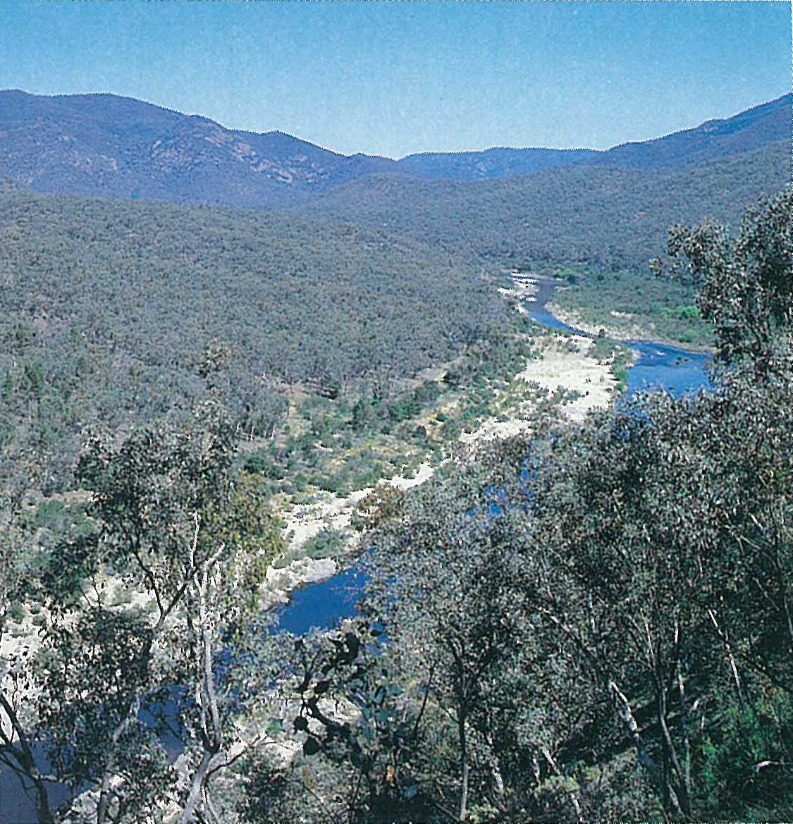
The upper Snowy River valley ‘rainshadow’ area, including the Suggan Buggan and Deddick River valleys, receives less than 700 mm of rain per annum and is mostly at less than 600 metres in altitude. The dry steep slopes with gravelly soils support a Callitris glaucophylla and Eucalyptus albens woodland. Either or both of these species may be dominant, with Callitris being most tolerant of harsh conditions. Callitris occurs with Eucalyptus albens on the eastern and south-western slopes, whereas the eucalypt forms pure stands on the southern and south-eastern slopes (Ashton 1969) (Plate 6h). Recruitment of Callitris seedlings is threatened by grazing pressure from rabbits. This association has a sparse shrub- and ground-layer, characteristically of small-leaved sclerophyllous plants (e.g. Lissanthe strigosa and Melichrus urceolatus) or of plants that rapidly respond to sporadic rains (e.g. Cheilanthes austrotenuifolia). Species of grasses that are common to the Riverina and north-eastern Midlands regions also occur in this association (such as Aristida ramosa, Dichanthium sericeum and Enneapogon nigricans).
A riparian form of this community occurs in coarse alluvial sands periodically inundated by floodwaters of the Suggan Buggan, Deddick and upper Snowy Rivers. Short-lived species, particularly weeds, are common (e.g. *Eschscholzia californica, *Hirschfeldia incana, *Petrorhagia velutina and *Verbascum thapsus). Woody riparian species include Calytrix tetragona, Eucalyptus blakelyi and Kunzea ericoides (Plate 6h).
The distinctiveness of rainshadow woodland from the surrounding vegetation can be observed when travelling north-east into the Snowy River valley on either the Snowy River Road or the Deddick River Road.
Forests
Lowland sclerophyll forest
The most abundant community in East Gippsland is an open-forest, occurring from near the coast to the foothills (80–400 metres altitude). The forest is dominated by Eucalyptus sieberi and E. globoidea, with many variants depending on aspect, drainage, soil type and altitude. The dominant sub-community between the Cann and Genoa Rivers has the Proteaceae well represented in the shrub-layer with Banksia marginata, B. serrata, B. spinulosa, Hakea sericea, Lomatia ilicifolia and Persoonia linearis. This sub-community occurs on siliceous, often quartz-rich, sands. Eucalyptus muelleriana characterizes another subcommunity that is associated with clay-loam soils near Cabbage Tree Creek and north-east of Mallacoota. Another sub-community is restricted to the west of Orbost and characterized by a combination of eucalypts (Eucalyptus cypellocarpa, E. globoidea, E. sieberi and E. tricarpa). Opportunistic species (e.g. Acacia spp., Gahnia sieberiana, Hierochloe rariflora, Platylobium formosum, Pteridium esculentum and Tetrarrhena juncea) often form very dense stands within the subcommunities. The presence of these species suggests that the area has been significantly disturbed by frequent fire and/or forestry operations. The distribution of some species appears to relate less to discernible ecological factors than to a general east-west gradient; for example, Eucalyptus gummifera and Angophora floribunda only occur in the far east of the region, and pure stands of Allocasuarina littoralis, although occurring in central Victoria and Wilsons Promontory, are more abundant within this lowland sclerophyll forest in East Gippsland than anywhere else in the state.
Dry sclerophyll forest
A diversity of foothill forests (200–900 metres altitude) is represented in this widespread community. No single eucalypt species characterizes all four subcommunities as recognized by Forbes, Walsh & Gullan (1982). However, one or more of a large number of species will be present, depending on the interaction of a number of environmental features. This association occurs on leached sands or sandy loams over clays, on the drier aspects. The association has a canopy height of 20–37 metres. The eucalypts commonly dominating this association include Eucalyptus cypellocarpa, E. dives, E. globoidea, E. macrorhyncha and E. sieberi. The shrub-layer is characteristically of small-leaved, sclerophyllous plants (e.g. Acacia, Banksia, Daviesia, Hakea, Platylobium and Pultenaea) that are frequently opportunistic. The ground-layer consists of small shrubs (e.g. Acrotriche serrulata, Astroloma humifusum and Epacris impressa) and coarse herbs (e.g. Dianella caerulea, Stypandra glauca). The ground-layer is usually sparse.
Wet sclerophyll forest
This forest contains the best developed stands of Eucalyptus cypellocarpa, E. denticulata, E. fastigata and E. obliqua. These tall open-forests (about 30–64 metres high) occur on cool, moist slopes, generally of a southerly aspect throughout the eastern ranges (200–1200 metres altitude) from near Mt Bowen through to Mt Coopracambra. They also occur near sea-level at Mallacoota. The most widespread subcommunity is characterized by Eucalyptus cypellocarpa and E. obliqua, with a well-developed tall shrub-layer of Bedfordia arborescens, Cyathea australis and Pomaderris aspera, less commonly of Dicksonia antarctica. This subcommunity is comparable with tall open-forests elsewhere in Victoria, except that certain species present here (e.g. Eucalyptus fastigata, Smilax australis and Tylophora barbata) are lacking in other parts of Victoria. Eucalyptus regnans, characteristic of the forests further west in Victoria, reaches its eastern limit in this region. It is common only in the Mt Elizabeth and Rodger River areas.
On the Errinundra Plateau and the Coast Range is an ecotonal forest that is transitional between the above wet sclerophyll forest sub-community and cool temperate rainforest. In mature stands, Eucalyptus denticulata and E. fastigata are emergent (30–70 metres high) over a scattered secondary tree-layer of Atherosperma moschatum, Elaeocarpus holopetalus and Acacia dealbata, with a well-developed shrub-layer of Dicksonia antarctica, Olearia argophylla, Tasmannia lanceolata and Telopea oreades. Ground-ferns are common, such as Blechnum wattsii, Histiopteris incisa and Polystichum proliferum.
A drier forest subcommunity is found in broad open gullies, usually containing minor watercourses, and is typically located on the more exposed slopes just north of the Errinundra Plateau. Eucalyptus croajingolensis and, to a lesser extent, E. cypellocarpa and E. obliqua are the dominant species. Species which characterize the shrub stratum of this subcommunity include Acacia mucronata, Daviesia ulicifolia and Pultenaea juniperina (Forbes, Walsh & Gullan 1982). A riparian subcommunity that is often dominated by tall Eucalyptus viminalis (up to 60 metres high) occurs near permanent, high-altitude watercourses that drain forests of the other subcommunities.
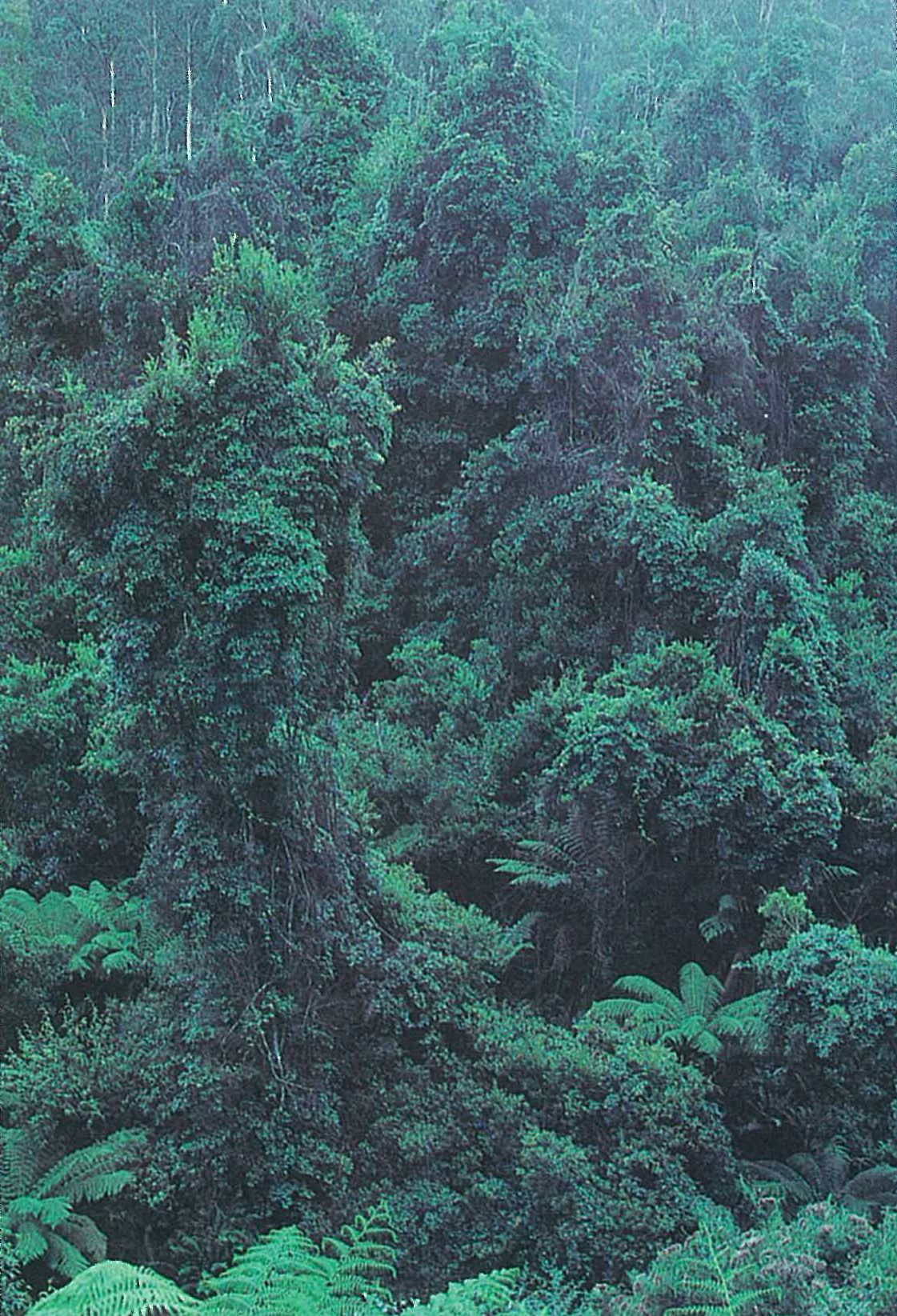
Warm temperate rainforest
Scattered throughout the lowland sclerophyll forest of the lowlands and foothills (40–700 metres altitude) occurs a closed-forest association dominated by Acmena smithii. Colloquially, these forests are often referred to as ‘jungle’. This community is classified as a warm temperate rainforest by Ashton (1969), Forbes, Gullan and Walsh (1981), Forbes, Walsh and Gullan (1982), and Webb (1959). It is restricted to the sheltered gullies and alluvial flats of major rivers, being more common east of the Snowy River to the Howe Range.
These forests are near the southern limit of a vegetation type that is more extensive within tropical regions. However, in this region they represent a depauperate and simplified version of their tropical equivalents. This community forms one of the few Victorian forest types not dominated by eucalypts. Acmena smithii forms a conspicuous, dark-green, uneven, closed canopy to a height of 20–30 metres. Other associated tree species include Acacia melanoxylon (frequently as a co-dominant), Bedfordia arborescens, Elaeocarpus reticulatus, Pittosporum undulatum, Pomaderris aspera, Rapanea howittiana and Tristaniopsis laurina. The tree canopy is usually tangled with woody vines or lianes (e.g. Cissus hypoglauca, Clematis aristata, C. glycinoides, Eustrephus latifolius, Marsdenia rostrata and Smilax australis) (Plate 6i). Ferns are prominent beneath the canopy (Wakefield 1944a, 1944b; Robbins 1945). Any of Victoria’s five species of tree-fern may occur (particularly Cyathea australis and Dicksonia antarctica), also ground-ferns (Blechnum cartilagineum, B. wattsii and Lastreopsis acuminata) and epiphytes (Microsorum pustulatum, M. scandens and Polyphlebium venosum) are common. Livistona australis (10–30 metres high) occurs in this association on the Brodribb River and Cabbage Tree Creek, near Marlo. This is the southernmost natural occurrence of this palm in Australia, with its nearest neighbours occurring some 300 km to the north (in New South Wales).
Many areas have been severely damaged by fire. The largest stands of warm temperate rainforest in Victoria occurred in the upper reaches of Jones Creek, near Genoa. However, this community was severely burnt by wildfire in early 1983, and whether complete recovery will occur is unknown (Parkes, Moorrees & Williams 1985). A well-known example of warm temperate rainforest occurs on the southern slopes of Mt Drummer in the Alfred National Park. Other localities include Martins Creek along the Bonang Highway, and Bemm River along the Combienbar Road. The most westerly occurrence of this community occurs in the Mt Moornapa Flora Reserve (Ashton & Frankenberg 1976; Seddon & Cameron 1985b). Nearby, in the Mitchell River State Park, floristically richer examples of this community occur. For further details of the localities and structure of the warm temperate rainforest refer to Seddon and Cameron (1985a, 1985b) and Cameron (1987).
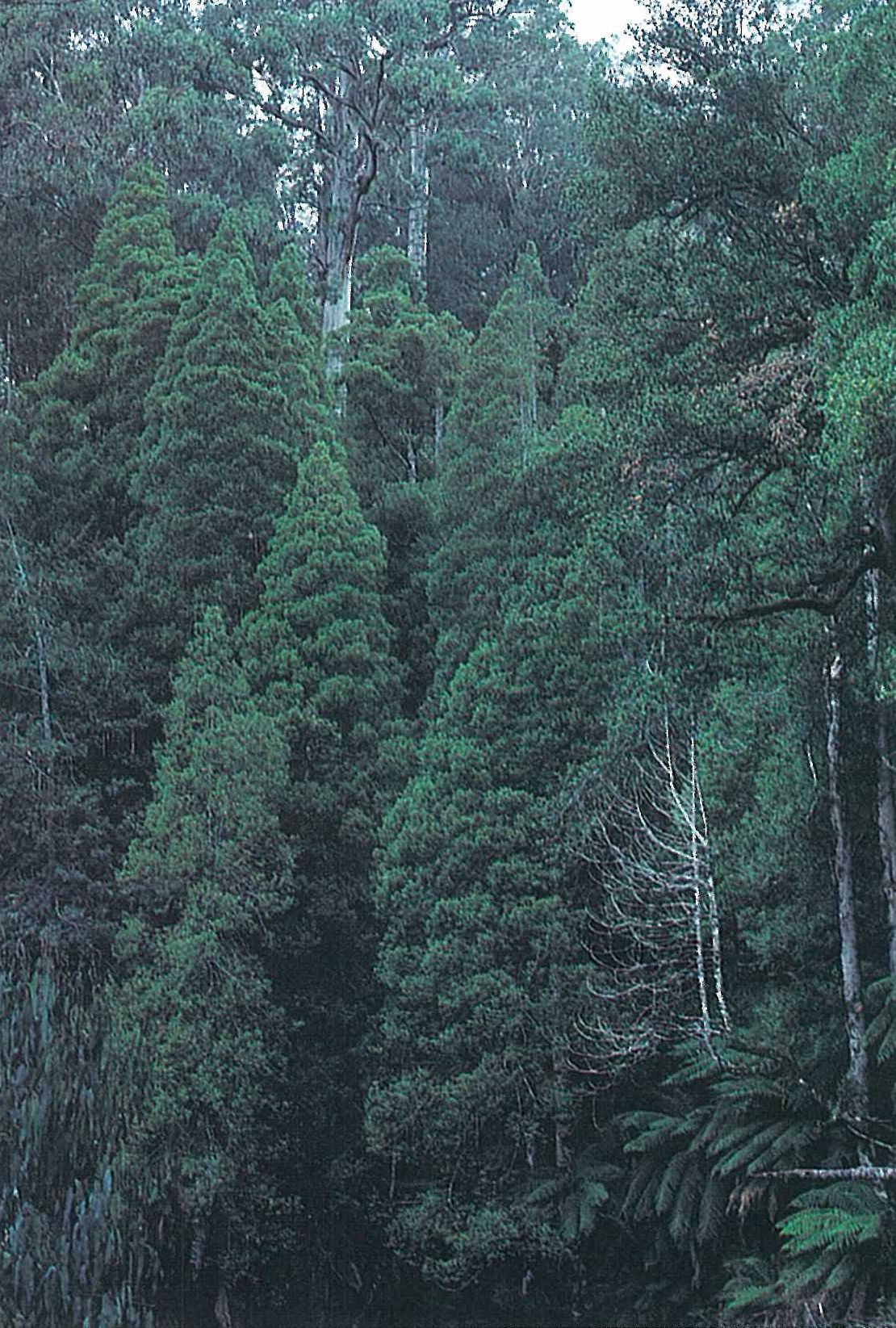
Cool temperate rainforest
A closed-forest of wet montane gullies and sheltered slopes occurs at higher altitudes (600–1000 metres altitude), predominantly on the Errinundra Plateau. This community is classified as a cool temperate rainforest by Ashton (1969), Forbes, Gullan and Walsh (1981), and Forbes, Walsh and Gullan (1982). It occasionally merges with the lower-altitude warm temperate rainforest. Cool temperate rainforest is dominated by Atherosperma moschatum and Elaeocarpus holopetalus, frequently with Eucalyptus denticulata as an emergent (Plate 6j). Acacia dealbata, Pittosporum bicolor, Tasmannia lanceolata and Telopea oreades are common shrubs to small trees. Lianes are rare or absent. Of the ferns, Dicksonia antarctica and Blechnum spp. (e.g. B. wattsii) dominate the understorey. Several epiphytic ferns are common (e.g. Asplenium bulbiferum and Polyphlebium venosum). Mosses are common on the tree-trunks, fallen logs and rocks (Ashton 1969).
In Victoria, the principal areas of cool temperate rainforest are found in this region, the Gippsland Highlands, Wilsons Promontory and the Otway Range. The last three regions support rainforests dominated by Nothofagus cunninghamii, whereas this species is absent from East Gippsland. The distribution of cool temperate rainforest within Victoria is given by Seddon and Cameron (1985a, 1985b) and Cameron, D. G. (1987).
Dense mossy rainforest thickets, with emergent Podocarpus lawrencei occur near Goonmirk Rocks, on the Goonmirk Range at an altitude of 1000 metres (Ashton 1969). The dominant shrubs of these thickets include Notelaea ligustrina, Prostanthera lasianthos, Tasmannia and Telopea. Podocarpus lawrencei, typically a low alpine shrub, grows to 17 metres high in the shelter of Atherosperma moschatum in one example of this interesting alliance.
Cool temperate rainforest is found in areas where the surrounding forest has not been burnt for a prolonged period, and some impressively old (at least 250 years) examples exist. This community is very susceptible to exposure resulting from fire or timber-harvesting activities which remove the protection given by adjacent forest.
Examples of cool temperate rainforest and wet sclerophyll forest on the Errinundra Plateau can be seen along the Errinundra Road and Coast Range Road, although mature stands are interspersed with young regrowth after timber harvesting.
Montane sclerophyll woodland and montane forest
A tall woodland or tall open-forest occurs on rocky, mountain soils in areas of low effective rainfall (Parkes, Moorrees & Williams 1985). This community is characterized by Eucalyptus dalrympleana, E. dives, E. pauciflora, E. rubida, and occasionally by E. obliqua (Figure 6.26). At higher altitudes the association tends to grade with Snow-gum woodland (characteristic of the Snowfields Region) and at lower altitudes, it merges with dry sclerophyll forest. There are isolated occurrences at Mt Tingaringy, Mt Bowen, and on the Gunmark Road (near Bendoc). The canopy is commonly dominated by Eucalyptus rubida (height 30–40 metres), with the other eucalypts forming an open second tree-storey (7–15 metres high). The common species of the tall shrub-layer are Daviesia ulicifolia, Leptospermum grandifolium, Leucopogon hookeri, L. maccraei, Monotoca scoparia, Olearia phlogopappa, Pultenaea juniperina and Tasmannia lanceolata.
A tall open-forest, characteristically dominated by Eucalyptus delegatensis, occurs at scattered localities throughout the region (e.g. Mt Delegate and Mt Ellery). This community has been more fully discussed in the Snowfields Region.
Riparian forest
An open-forest occurs on the wet slopes and river banks of most of the major lowland watercourses in the region. This community is floristically rich, usually with a high percentage of weedy species (particularly *Rubus fruticosus spp. agg.—Blackberry). Species that commonly occur include Acacia melanoxylon, Blechnum nudum, *Centaurium tenuiflorum, Coprosma quadrifida, *Hypochoeris radicata, Lomandra longifolia, Pomaderris aspera, Pteridium esculentum, Tetrarrhena juncea and Tristaniopsis laurina. Riparian forest can be seen on the Tambo River along the Omeo Highway, and on the Brodribb River along the Bonang Highway.
Land use
The lower reaches, floodplains and some of the valleys of the major river systems have been cleared for pastoral agriculture (particularly for the beef and dairy industries). Sheep grazing occurs in the drier north-western part of the region. Market gardens are concentrated in the river and creek valleys, and particularly on the alluvial flats of the Snowy River near Orbost. Utilization of the hardwood forests for timber has a long history in the region, starting in the 1850s at Bendoc (Anon. 1974a). This and tourism are the major industries for the region.
National Parks
- Alfred—3050 ha; Alpine (in part)—627 680 ha;
- Croajingolong—87 500 ha;
- Errinundra—25 600 ha; Lind—1365 ha;
- Mitchell River— 11 900 ha;
- Snowy River—98 700 ha.
State Parks
- Coopracambra—38 800 ha;
- Lake Tyers (proposed)—7100 ha (plus proposed addition of 1300 ha);
- Sydenham Inlet Coastal Park (proposed)— 12 600 ha.
Source: Conn, B.J. (1993) Natural regions and vegetation of Victoria, in: Foreman, D.B. and N.G. Walsh (eds), Flora of Victoria Volume 1, pp. 79–158, Inkata Press.