Wilsons Promontory
Location
This region is the most southerly part of mainland Australia. The north-western and northern boundary includes the Darby River (west coast) and the south-west corner of Corner Inlet. The remaining promontory to the south of this boundary constitutes the region. The low, sandy, Yanakie Isthmus that connects this southern, granitic mountainous mass to the mainland is excluded from the region, even though it is part of the current National Park. The islands included in this region are Doboy (Doughboy), Benison and Granite (in Corner Inlet); Shellback (west coast), Rabbit, and the Seal Group (east coast), and all islands north of Rodondo and the Hogan Group.
Major grid T. Approximate area 410 km2.
Major landforms
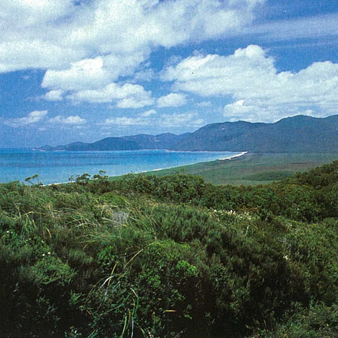
Wilsons Promontory is composed entirely of early Devonian granitic bedrock, with superficial and localized deposits of Quaternary sediments (particularly sands and peats) (Brownlie & Brownlie 1973, p. 15; Wallis 1980). The granites are the northern limits of a formation extending to north-eastern and eastern Tasmania. The topography is dominated by the exposed and weathered, rugged granitic mountains and hills. Water and wind erosion along fault lines and joints has resulted in valleys (such as Lilly Pilly Gully) and rounded tors (particularly evident along the Boulder Range). The highest point is Mt Latrobe at 754 metres. The Quaternary deposits occupy relatively small areas of the Promontory. They are composed of yellow calcareous sands (to the west of the Promontory), white siliceous sands (mainly to the east, e.g. the beaches at Oberon and Waterloo Bays, with Squeaky Beach on the west coast an exception), calcarenites (cliffs at Darby Bay and extending to Shellback Island), and peats (e.g. in the Darby River area). The present beaches have resulted from recent and current sand deposition. Alluvial and swamp deposits have also formed from the deposition of weathered granite mountains and hills. Swampy areas occur in the low-lying area north of Mt Vereker and inland of coastal dunes behind most beaches (e.g. Sealers Cove and Tidal River).
Climate
Wilsons Promontory experiences a comparatively mild climate with moderate temperatures characteristic of a maritime environment. The mean maximum temperatures at Tidal River range from 24°C in February to 13°C in July. The mean minima range from 13°C in February to 6°C in August (Ashton & Webb 1977). Frosts are rare. Precipitation is generally reliable with the maximum rainfall occurring during winter (mean annual rainfall about 1090 mm). The precipitation above 300 metres is often enhanced by low cloud and mist. Snowfalls are rare on Mt Latrobe. Typical of other exposed coastal areas, this region experiences strong winds that are mainly westerlies and fluctuate from north-west to south-west. See also ‘Climate of Victoria’ (this volume).
Vegetation
The vegetation of this region and that of the nearby Gippsland Highlands are very similar. The more mountainous parts of both regions have forests of Eucalyptus baxteri, E. globulus, E. regnans and Nothofagus cunninghamii, as well as fern gullies.
Forests
Tall forests, probably of Eucalyptus baxteri, E. globulus, E. muelleriana and E. regnans, with highly developed fern gullies, would have covered the slopes in the past (Willis in Anon. 1969). However, only remnants of these mountain forests and fern gullies remain. The bush-fires of this century have been so intense and frequent that these tall forests will probably never regenerate. Tall forests (including large trees of E. globulus) once occurred at Pillar Point (Garnet 1971). Today, this area is reduced to a salt-pruned, stunted woodland (see below). The more heavily timbered parts of the region occurred mainly on the eastern (leeward) side of the mountains (e.g. on the eastern slopes of the ranges to the west of Sealers Cove). On the lower eastern slopes (near Sealers Cove) large logs are all that remain of a tall forest (Garnet 1971). Audas in Ewart (1910) observed trees of Eucalyptus muelleriana (incorrectly referred to as E. pilularis) about 200 feet (60 metres) high at Sealers Cove. Other large trees that he listed from this area were E. globulus, E. macrorhyncha and E. viminalis. A Leptospermum continentale–Kunzea ambigua heathland now occurs in this area. Eucalyptus macrorhyncha (Audas in Ewart 1910) and E. sieberi (Willis in Anon. 1969) once grew near Sealers Cove, but have not been recorded since 1909. Large areas support populations of E. obliqua introgressed with E. regnans (Otway Messmate) (Ashton, pers. comm. 1988).
Cool temperate rainforest
Cool temperate rainforest occurs at Sealers Cove, Refuge Cove (both of the east coast), Mt Latrobe (Figure 6.21), Mt Ramsay and Fraser Creek (which flows into Oberon Bay on the west coast). The Nothofagus cunninghamii-dominated closed-forest consists of only a few species forming a canopy of 8 to about 42 metres. Tall Acacia melanoxylon (often not common), Atherosperma moschatum and Pomaderris aspera occur as co-dominants or as understorey trees, together with Pittosporum bicolor. Common understorey shrubs include Coprosma quadrifida, Hedycarya angustifolia, Olearia lirata, O. phlogopappa and Tasmannia lanceolata. A tree-fern association frequently develops in many of the shady gullies. Characteristically, these fern gullies are dominated by Cyathea australis, Dicksonia antarctica and Todea barbara, often with some Cyathea cunninghamii. The ground-layer is characteristically composed of a rich fern flora (e.g. Asplenium bulbiferum, A. flabellifolium, Blechnum fluviatile, B. wattsii, B. patersonii, Ctenopteris heterophylla, Grammitis billardieri, Microsorum pustulatum, M. scandens and Polyphlebium venosum), together with Gahnia clarkei (Howard & Ashton 1973; Howard & Hope 1970). On the sheltered aspects of the summit of Mt Latrobe occurs a low closed-forest of Nothofagus cunninghamii (3–4 metres high) in humus-rich soils. The associated shrubs include Callistemon pallidus, Epacris impressa, Monotoca elliptica, Olearia stellulata and Tasmannia lanceolata. The herb-layer consists of Blechnum wattsii, Dianella tasmanica, Gahnia sieberiana and Libertia pulchella, plus numerous bryophytes and lichens. However, much of the summit of Mt Latrobe is strewn with stumps, and fallen and burnt trunks of Nothofagus cunninghamii, plus Eucalyptus obliqua. These are closely associated with the exposed, grooved tors. Ashton and Webb (1977) suggest that it is likely that before the fires of this century, the boulders of this mountain top were largely clothed with humus-rich moss mats, thick enough and moist enough to sustain tree roots for long periods. The presence of the E. obliqua stumps suggests that this species formed an overstorey to the rainforest. An interesting wind-sheared Nothofagus heathland (1 metre high) occurs amongst the rocks on exposed western slopes of this mountain. The associated shrubs and herbs are similar to those found in the N. cunninghamii low closed-forest (see above).
Warm temperate rainforest
The depauperate form of warm temperate rainforests dominated by Acmena smithii on Wilsons Promontory represent the most southerly extension in Australia of this tropical element (Ashton & Frankenberg 1976). The only other tropical representative is the tree species Elaeocarpus reticulatus which extends to Tasmania. The structure of these forests is relatively simple, with the dense canopy reaching 20–27 metres on well-drained sites. On wetter sites the understorey is often composed of suppressed seedlings and saplings of Acmena smithii. Common understorey species include Coprosma quadrifida, Pittosporum bicolor, Olearia argophylla, Cyathea australis, Dicksonia antarctica and Todea barbara—the latter three tree-ferns are particularly common in many of the shady gullies and watercourses. Lepidosperma elatius is very common, and forms large, tall communities in the fern gully at Sealers Cove (Garnet 1971). On drier sites, the understorey is usually poorly developed, except in gaps in the canopy, and the floor of the forest may be covered solely with litter. Australina pusilla, Gahnia clarkei, Polystichum proliferum and Tetrarrhena juncea are confined to these gaps. Clematis aristata, C. glycinoides and Parsonsia brownii are common lianes. An overstorey of emergent Acacia melanoxylon and Eucalyptus obliqua (most common), E. muelleriana or E. globulus (on better-drained sites) and E. ovata (on poorly-drained sites) is present. The ground-layer is dominated by ferns (e.g. Blechnum nudum, B. wattsii, Microsorum pustulatum and M. scandens), including the filmy ferns Hymenophyllum australe, H. cupressiforme, H. flabellatum, Macroglena caudata and Polyphlebium venosum.
This community mostly occurs along the streams and flats radiating from the Mt Latrobe–Mt Ramsay massif, and the foothills of the Vereker Range. Particular sites include China-mans Creek (Figure 6.22), Darby River, Lilly Pilly Gully and Sealers Cove.
Eucalyptus obliqua-dominated wet sclerophyll forest
Eucalyptus obliqua is the dominant species on the cooler sites, particularly above elevations of 500 metres. The understorey of these tall open-forests is dominated by wet sclerophyll forest shrubs such as Pomaderris aspera and Zieria arborescens. The original forest of Eucalyptus obliqua has largely been decimated on Mt Ramsay and has been replaced by a shrubland of Olearia stellulata and Epacris impressa (Ashton & Webb 1977).
Eucalyptus obliqua/E. baxteri-dominated dry sclerophyll forest
A low open-forest (4–6 metres high), dominated by Eucalyptus obliqua, occurs on drier sites than those of the previous community. This community often has E. baxteri as a co-dominant, although, characteristically, the latter species tends to occur in the drier areas (e.g. North Tidal Overlook). A low open-forest dominated by E. baxteri occurs on deep gravelly outwash soils of the lower westerly slopes of Mt Bishop.
Woodlands
Banksia integrifolia
Banksia integrifolia and B. serrata occur either occasionally in the Leptospermum laevigatum thickets (e.g. at Tidal River) (Figure 6.23) or in small woodlands (up to 12 metres high) on calcareous sands (e.g. near Darby River). The ground-layer species include Dichondra repens, Isolepis marginata, Pteridium esculentum and other herbaceous species (particularly orchids).
Eucalyptus baxteri
This species forms an association between some heathlands and the drier sclerophyll forests, on siliceous sands or gradational and duplex soils. Eucalyptus baxteri occurs as a stunted form in low shrubby thickets (up to 2 metres high) or as low trees. E. willisii and Allocasuarina verticillata occur occasionally throughout the upperstorey of these woodlands (particularly in shallow soils near granite outcrops). Common understorey species include Acacia suaveolens, Allocasuarina paludosa, Amperea xiphoclada, Banksia marginata, B. spinulosa, Billardiera scandens, Correa reflexa, Gonocarpus tetragynus, Hakea sericea, Kunzea ambigua, Lepidosperma laterale, Leptospermum continentale, Lomandra filiformis, Spyridium parvifolium and Xanthorrhoea australis. The richer (less sandy) soils support taller woodlands, with the trees 10–18 metres high. Although Eucalyptus baxteri usually dominates this formation, E. obliqua and E. willisii may also be present as co-dominants. A mixed, stunted E. baxteri–E. obliqua–E. willisii woodland occurs on the granite-derived soils of Pillar Point (north of Tidal River).
Heathlands and thickets
Allocasuarina pusilla–Leptospermum myrsinoides heathlands
These two species form low (about a metre high) dense heathlands on the siliceous parabolic dunes and deeper sand sheets (e.g. at Tidal River) (Figure 6.23). It is the most widespread association that occurs on moderately well-drained sites. This association is often replaced by Eucalyptus baxteri woodland and then Melaleuca squarrosa thickets on sites with increasingly poor drainage (Parsons 1966, pl. 37, fig. 3). Other species that commonly occur in this association are Banksia marginata, Epacris impressa, Hakea sericea, Hypolaena fastigata, Isopogon ceratophyllus, Leucopogon ericoides, L. virgatus, Lomandra filiformis and Xanthorrhoea australis (Plate 6d).
Eucalyptus baxteri frequently occurs as emergent shrubs at mid-dense to open densities, forming a community which is structurally intermediate between the heathland and the E. baxteri-dominated woodland.
Leptospermum laevigatum thicket
Thickets of Leptospermum laevigatum occur on calcareous sands (e.g. at Tidal River) (Figure 6.23) behind the current beaches (Costermans 1981; Parsons 1966). The main species associated with this formation is Leucopogon parviflorus, usually occurring as a tall shrub or an undershrub. The thickets are up to about 8 metres high. Parsons (1966) records the following understorey species: Acaena sp., Clematis microphylla, Correa alba, Dichondra repens, Geranium potentilloides, Lepidosperma glacliatum, Lomandra longifolia, Muehlenbeckia adpressa, Poa sp., Senecio glomeratus, Solanum aviculare, Swainsona lessertiifolia and Viola hederacea. Scattered occurrences of Allocasuarina verticillata also occur in this community.
Leptospermum laevigatum also occurs on the siliceous parallel sand dunes and on the exposed north-western granitic slopes of Mt Oberon. The thickets on Mt Oberon are lower and more open than those on the dunes. This latter association grades into Eucalyptus baxteri low-woodland.
Melaleuca ericifolia thicket
Thickets of Melaleuca ericifolia occur on soils ranging from peaty sands to amorphous peats (Parsons 1966). At Tidal River (Figure 6.23), they are found inland from the saltmarsh and attain a height of about 8 metres. In the more saline conditions, the understorey is predominantly of saltmarsh species (e.g. Samolus repens, Sarcocornia quinqueflora and Selliera radicans). Further inland, scattered tall shrubs of Acacia verticillata and understorey species of Gahnia, Goodenia ovata and Poa spp. dominate the thicket. In drier sites Melaleuca squarrosa replaces M. ericifolia.
Melaleuca squarrosa thicket
This association is the most widespread of the swamp communities. It occurs adjacent to Melaleuca ericifolia thickets on the better-drained sites, in peaty sands to amorphous peats (Figure 6.23). The thickets are usually about 4 metres high, with scattered plants of Acacia verticillata and Ozothamnus ferrugineus. The understorey is dominated by Gahnia spp. Other common understorey species include Bauera rubioides, Billardiera scandens, Empodisma minus, Gleichenia microphylla, Goodenia ovata, Gonocarpus tetragynus, Leptospermum continentale, Leucopogon australis, Phragmites australis and Pultenaea stricta. On fibrous peats Melaleuca squarrosa forms a lower (up to 2 metres high), more open formation (the Melaleuca squarrosa heath association of Parsons 1966). The understorey comprises several sedges (e.g. Cladium procerum, Gahnia spp., Gymnoschoenus sphaerocephalus and Lepidosperma forsythii).
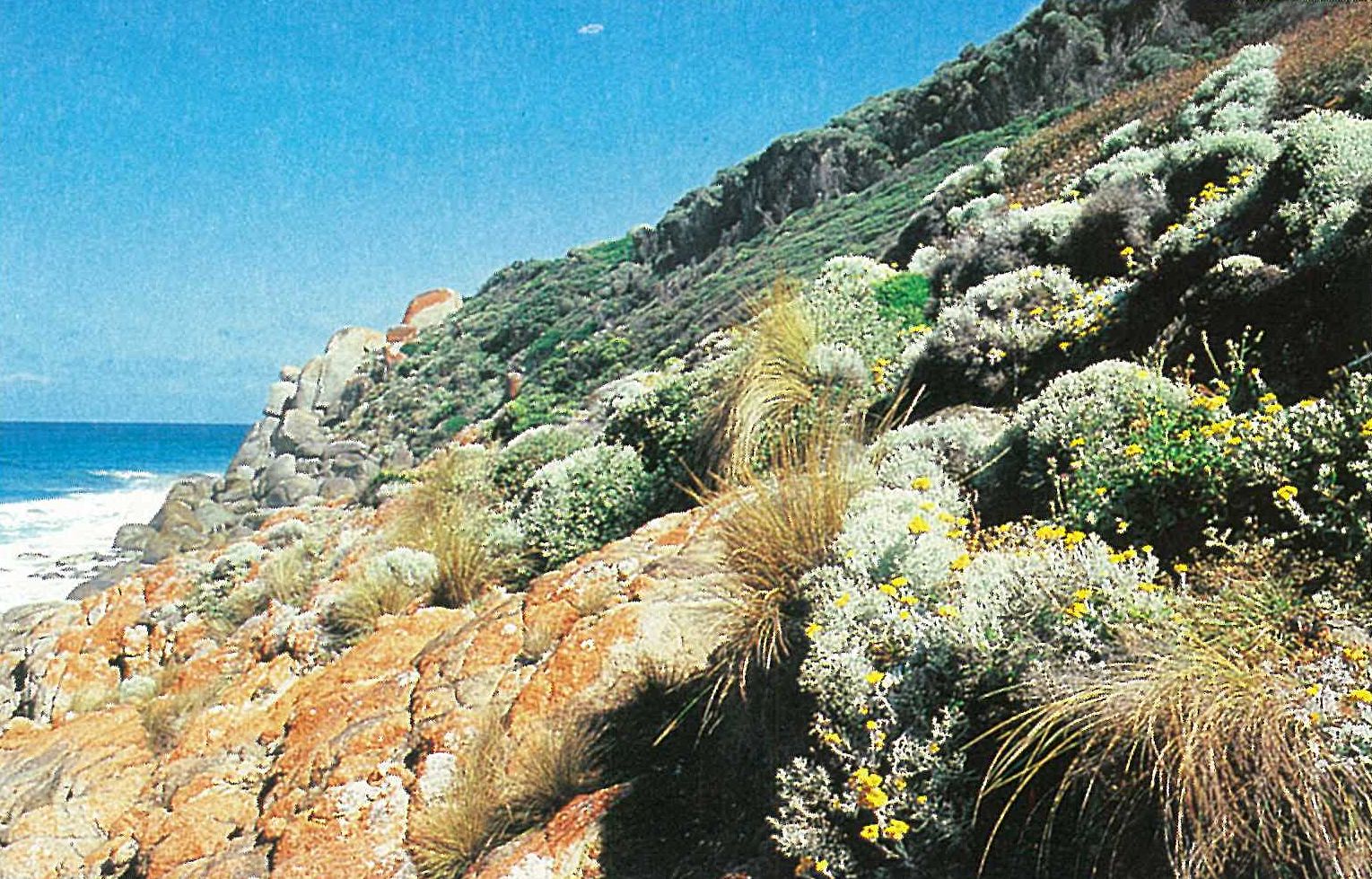
Granite outcrop heathlands
The granitic outcrops on the spurs and summits of Wilsons Promontory are characterized by Kunzea ambigua (at elevations below 400–500 metres) and Callistemon pallidus (above about 300 metres). These two sclerophyllous shrubs occur in the shallow soils surrounding the rock outcrops. The herb-layer is dominated by bryophytes, lichens, annuals and geophytes. In the salt-affected coastal fringe, Carpobrotus rossii, Disphyma crassifolium subsp. clavellatum and a succulent form of Senecio lautus are common in the shallow soils (Plate 6e). In more sheltered areas of Allocasuarina–Leptospermum heathland (see above), Kunzea ambigua-dominated heathland is usually present as an intermediate zone around the granite outcrops. These rock-heaths also occur in Eucalyptus baxteri forests/ woodlands and E. obliqua forests above elevations of 300 metres. Callistemon pallidus rock-heaths occur on the southern aspects of Mt Oberon, associated with Leptospermum continentale.
Saltwater communities
Juncus kraussii–Samolus repens-dominated saltmarsh
Saltmarsh communities occur on undifferentiated sands and sandy peats (e.g. Tidal River). The formation is dominated by Juncus kraussii, Samolus repens, and locally often by Sarcocornia quinqueflora and Stipa stipoides, with Selliera radicans and Gahnia filum as common associates. Small halophytic communities (including Atriplex spp., Disphyma crassifolium subsp. clavellatum and Rhagodia candolleana) occur in the crevices of elevated rock platforms along the west coast (e.g. near Picnic Point), on the offshore islands (see below), in some tidal estuaries (e.g. Tidal River) and along the shores of Corner Inlet. Other species that occur scattered throughout these salty areas include Correa alba, Leucophyta brownii and Poa poiformis (e.g. at Tongue Point) (Plate 6e).
Mangrove
The muddy coastline in Corner Basin (Corner Inlet) supports a saltmarsh with some fringing mangroves of Avicennia marina. (For further details on this community refer to the description for the Gippsland Plain)
Granite islands
All the Promontory islands are granitic (Gillham 1961; Norman 1971; Wallis 1980). The vegetation of these islands is usually a low tussock-grassland or low shrubby thicket.
Poa poiformis-dominated closed-tussock-grassland
The tussock community is usually monospecific. Occasionally, Alyxia buxifolia, Apium prostratum, Bulbine bulbosa and Correa alba occur in sheltered crevices within this association (Dannevig Island—Norman, Brown & Deerson 1980). Other occasional associates include Disphyma crassifolium subsp. clavellatum, Leptospermum laevigatum, Lobelia alata, Pseudognaphalium luteoalbum, Senecio lautus and *Sonchus oleraceus (Citadel Island—Norman & Brown 1979) or *Hypochoeris radicata and Pelargonium australe (Hope & Thompson 1971).
Leptospermum laevigatum thicket
This species forms a mixed shrubby association on most of the islands. Frequently the association forms several disjunct communities (e.g. Wattle Islands—Norman, Brown & Deerson 1980). This association is usually extremely dense, often 2–3 metres high, commonly with Correa alba and *Paraserianthes lophantha.
Disphyma crassifolium subsp. clavellatum-dominated halophytic herbfield
This association forms a distinctive, low closed sward on most islands. It forms a dense community when established in soil, but when established in crevices the community is more open, with the plants extending across the sloping rock-face (Norman & Brown 1979; Norman, Brown & Deerson 1980). A few species are sometimes associated with this community (e.g *Hypochoeris radicata, Lobelia alata and *Sonchus oleraceus—on Cliffy Island). Small areas of Sarcocornia quinqueflora often occur in exposed westerly areas (Hope & Thompson 1971).
Land use
The conservation of the natural features of the region is ensured since the entire region is included in the Wilsons Promontory National Park. The region provides important opportunities for recreation and education.
National Park
- Wilsons Promontory (excluding Yanakie Isthmus)—49 000 ha.
State Park
- Wilsons Promontory Marine Reserve and Marine Park (in part)—10 000 ha.
Source: Conn, B.J. (1993) Natural regions and vegetation of Victoria, in: Foreman, D.B. and N.G. Walsh (eds), Flora of Victoria Volume 1, pp. 79–158, Inkata Press.