Gippsland Plain
Location
This region includes the area south of the mountainous country of the Eastern Highlands (below elevations of about 200 metres) to the Victorian coast of Bass Strait, excluding the Strzelecki Ranges (included in the Gippsland Highlands) and Wilsons Promontory. The eastern boundary between this region and East Gippsland has been arbitrarily defined as the eastern shoreline of the lakes from Lakes Entrance to the mouth of the Tambo River (at Lake King), then the Princes Highway to Lucknow, west along the Lucknow to Iguana Creek Road, with Stockdale the most westerly point. The western boundary between this region and the Victorian Volcanic Plain Region is largely defined by the geological boundary between the Upper Cainozoic (Quaternary) basalts (Newer Volcanics of the latter region) and the marine and non-marine Cainozoic alluvia, including the fluviatile sands and gravels of this region. Much of the Port Phillip Bay Sunkland and neighbouring non-volcanic sediments are included in the region.
Major grids N, P, S, T, W and X. Approximate area 15 054 km2.
Major landforms
Much of the region consists of flat to slightly undulating Cainozoic sediments that form a coastal plain. The plain to the west of the Strzelecki Ranges gently slopes to the west, whereas those to the east gently slope to the east. In the eastern parts of the region, the fluviatile sands and gravels of plains are underlain by marine Cainozoic sediments. In the central area the Cainozoic sediments are non-marine and consist of lignites (brown coals), clays, sands and gravels (Hills 1940; Gibbons and Rowan, this volume). Details of the geological history of the region are given in Anon. (1972b, 1980b), Jenkin (1971) and Douglas (this volume).
Climate
The region experiences a temperate climate with a transition from a winter rainfall maximum (in the western parts) typical of the southern Australian coastline to the more uniform rainfall (in the eastern parts) of coastal south-eastern Australia. Mean annual rainfall varies from about 550 to 1120 mm, with the wettest months usually being from May to October. The area to the east of the Strzelecki Ranges is in a rainshadow zone. For example, there is a decrease in the mean annual rainfall from Madalya in the Gippsland Highlands to Yarram in this region (a distance of 18 km) of 500 mm. There is a further decrease in the mean annual rainfall of 170 mm from Yarram to Seaspray (to the east) (Anon. 1980b). A similar decrease in rainfall occurs from west to east in the Latrobe Valley. The temperatures are relatively mild throughout the region, with the highest temperature maxima usually occurring in the Latrobe Valley and, in general, inland from the coast. Typical mean daily maxima range from 13°C to 26°C, with mean daily minima ranging from 3°C to 15°C. July is the coldest month, and February the warmest. Frosts are relatively infrequent near the coast, becoming more frequent and severe inland. See also ‘Climate of Victoria’ (this volume).
Vegetation
The vegetation has been significantly disturbed, or totally removed over large areas, for agricultural purposes. In the western part of this region, particularly around Port Phillip Bay, an ever-increasing area is being alienated by residential and industrial development.
Forests and woodlands
Damp/wet sclerophyll forests
Eucalyptus viminalis dominates an open-forest on immature, stream-line soils (mean annual rainfall 780–990 mm), in gullies of permanent streams on the Mornington Peninsula. E. obliqua is often a co-dominant, or is associated with this community. The ferns of the understorey consist of Blechnum nudum, Calochlaena dubia, Cyathea australis and Pteridium esculentum. Other understorey and ground-layer species include Acacia dealbata, Clematis aristata, Coprosma quadrifida, Olearia argophylla, O. lirata, Pandorea pandorana, Parsonsia brownii, Poa labillardieri, P. sieberiana, Pomaderris aspera and Rapanea howittiana. Many of these species are absent or uncommon in the other communities on the Mornington Peninsula. Most of the few remnants of this community are seriously disturbed.
An open to tall open-forest commonly occurs on well-drained, sandy loam soils in flat to undulating country of the Strzelecki Ranges (Gippsland Highlands), and extends south into the Gippsland Plain. This community is extremely variable, both floristically and structurally. Since the destruction of most of the wet sclerophyll forest (either through clearing by early settlers or by bushfires), damp sclerophyll forest has become the most heavily utilized community for timber production and allied forest products (e.g woodchips) (Gullan et al. 1984, 1985). The dominant eucalypts include Eucalyptus consideniana, E. cypellocarpa, E. obliqua and E. radiata. The understorey is commonly dominated by Acacia dealbata, A. mucronata, A. verticillata, Billardiera scandens, Cassinia aculeata, Epacris impressa, Gahnia radula, Gonocarpus tetragynus, G. teucrioides, Goodenia ovata, Lomandra filiformis, L. longifolia, Platylobium formosum, Pteridium esculentum, Pultenaea juniperina and Tetrarrhena juncea. Opie et al. (1984a, 1984b) recognize several subcommunities on French Island. Eucalyptus cypellocarpa/E. obliqua-dominated damp sclerophyll forest extends from the Dandenong Ranges (Eastern Highlands) to the undulating lowlands of the eastern suburbs of metropolitan Melbourne. Although it is hard to imagine now, E. obliqua once grew at Hawthorn (Jones et al. 1986). The E. cypellocarpa/E. obliqua community is not common in this region, but in general occurs as outliers of those found in the Gippsland Highlands or the Eastern Highlands.
Dry sclerophyll forest
The dry sclerophyll forests are open-forests which occur throughout the region. The eucalypts that dominate the community include Eucalyptus obliqua, E. radiata and E. viminalis. In the wetter areas (mean annual rainfall 900–1100 mm), the community is dominated by E. obliqua, E. globoidea and E. radiata (e.g. in the Pakenham area), where it occurs on deep loam soils or shallow, rocky soils of gently sloping ground (50–200 metres altitude). The understorey and ground-layer are usually very open and are dominated by grasses (e.g. Deyeuxia quadriseta, Imperata cylindrica, Microlaena stipoides and Poa spp.,), and small shrubs and herbs (e.g. Acacia stricta, Acrotriche prostrata, Adiantum aethiopicum, Cassinia aculeata, Dichondra repens, Epacris impressa, Glycine clandestina, Gonocarpus tetragynus, Lomandra filiformis, L. longifolia, Pteridium esculentum, Senecio quadridentatus and Viola hederacea). In drier areas (e.g. Holey Plains, mean annual rainfall 620–780 mm), this community occurs on loam to sandy-loam soils (80–200 metres altitude). Here, the dominant canopy species are Eucalyptus globoidea and E. consideniana. The understorey is very species-poor, with dense stands of Gahnia radula, Kunzea ericoides and Pteridium esculentum. Other common species include Hibbertia acicularis, Lomandra filiformis, Monotoca scoparia, Pimelea humilis and Xanthorrhoea minor. This latter subcommunity is severely disturbed and supports fewer species than it would have in pre-European times (Opie et al. 1984a, 1984b).
The dry sclerophyll forest community on the Mornington Peninsula has been extensively cleared for agriculture. Remnants of Eucalyptus obliqua/E. radiata-dominated open-forest or woodland occur in strongly acidic, sandy soils on the Mornington Peninsula. The understorey is dominated by Acrotriche serrulata, Epacris impressa, Hydrocotyle laxiflora, Poa labillardieri, P. sieberiana, Pteridium esculentum, Viola hederacea and Xanthorrhoea australis. Other open-forest alliances on the Mornington Peninsula include a Eucalyptus obliqua-dominated dry sclerophyll forest that occurs on yellow podsolic soils derived from basalt or granite (mean annual rainfall 780–970 mm) (Calder 1986). This alliance has a similar, but denser and more species-diverse understorey than the previous alliance. The other common understorey species are Acacia verticillata, Billardiera scandens, Hypericum gramineum, Leptospermum continentale and Ozothamnus ferrugineus. This alliance also occurs on deep krasnozem soils (mean annual rainfall 860–1000 mm) (Calder 1986). Eucalyptus cephalocarpa, E. dives, E. macrorhyncha and E. polyanthemos dominate a dry sclerophyll forest alliance that occurs on the skeletal soils of the undulating lowlands and foothills in the eastern suburbs of Melbourne.
Grassy woodland
An open-forest or woodland community is found on flat to gently undulating, well-drained loams to clay-loam soils. The dominant eucalypts include Eucalyptus bridgesiana (sensu lato), E. muelleriana (both characteristic of the alliance to the south and east of the Strzelecki Ranges), E. radiata and E. viminalis (the latter two being characteristic of the alliances to the north of the Strzelecki Ranges) and occur over an understorey largely of grasses (e.g. *Cynosurus echinatus, *Holcus lanatus, Microlaena stipoides, Poa spp. and Themeda triandra), other monocotyledons and herbaceous dicotyledons (e.g. *Cirsium vulgare, Dichondra repens, Gahnia radula, Gonocarpus tetragynus, Hydrocotyle laxiflora, Lomandra filiformis, L. longifolia, Oxalis spp., Pteridium esculentum, *Stellaria media and *Trifolium spp.). Shrubs are locally abundant but not usually dominant in the understorey. Common shrubs include Acrotriche serrulata, Astroloma humifusum, Bossiaea prostrata, Hibbertia riparia, Leptospermum continentale, Pimelea linifolia and Xanthorrhoea minor. Because of the relatively flat terrain on which this community is found, small depressions may become seasonally waterlogged. In these depressions Eucalyptus ovata is usually the dominant tree species, and a Melaleuca ericifolia shrubland community can develop beneath it. A grassy woodland dominated by Allocasuarina verticillata once occurred over large areas of the Mornington Peninsula (Calder, W. 1986), and occurred as a narrow band from Maribyrnong to Williamstown (Jones et al. 1986). Only remnants of this community remain. The understorey and ground-layer include Acacia retinodes, Clematis microphylla, Dichondra repens, Leptospermum laevigatum, Leucopogon parviflorus, Melaleuca lanceolata, Pimelea serpyllifolia, Poa poiformis and Swainsona lessertiifolia.
Remnant stands of Eucalyptus camaldulensis-dominated grassy woodland occur at Dandenong, Essendon (Napier Hill), Gellibrand Hill, Balwyn (Belmont Park), Bundoora (Gresswell Flora Reserve), and many individual old trees persist throughout the suburbs (e.g. along Glen-ferrie Road in Kooyong (Jones et al. 1986). An E. leucoxylon-dominated alliance still occurs at Studley Park, even though the area is now heavily infested by alien plants.
Eucalyptus tereticornis woodland/open-forest, with a Themeda triandra understorey, was once very extensive on the Traralgon–Sale plains. Large areas of Themeda-dominated grassland (without trees) once occurred in a mosaic with Eucalyptus tereticornis open-forest in the Stratford area (Scarlett, pers. comm., 1988).
A Eucalyptus pauciflora–E. rubida–E. ovata grassy woodland once occurred between Traralgon and the Haunted Hills on yellow solodic soils (Scarlett, pers. comm. 1988). This community has been largely eliminated, and only remnants survive along roadsides. E. bridgesiana {sensu lato) dominated the more elevated areas.
Grassy woodland has been heavily grazed throughout its range in the region. As a consequence, it is the most fragmented and weedy of the communities in this region.
Coast Banksia woodland
Banksia integrifolia dominates a low open-forest to woodland on well-drained, nutrient-deficient calcareous sands, inland of the primary dunes of coastal areas (mean annual rainfall 700–800 mm) (e.g. along the leeward side of the Ninety Mile Beach). The understorey is dominated by smaller sclerophyllous shrubs (e.g. Astroloma humifusum, Hibbertia sericea and Leucopogon parviflorus), herbs (e.g. Carpobrotus rossii, *Conyza bonariensis, Dichondra repens, Galium propinquum, Leucophyta brownii, Lomandra longifolia, Pteridium esculentum, Rhagodia candolleana and Senecio lautus), grasses (*Aira caryophyllea and Poa spp.) and sedges (e.g. Isolepis marginata, I. nodosa, Lepidosperma concavum and L. gladiatum). The introduced grass *Ammophila arenaria is commonly planted as a sand-binder. The frequency of the native Spinifex sericeus appears to have decreased since the introduction of the former grass (Gullan, Walsh & Forbes 1981). This community is now relatively uncommon in central Gippsland because the land has been cleared right up to the coastline. The community occurs on the south-west coast of Westernport Bay (between Sandy Point and Flinders), at the mouth of Bruthen Creek and on Snake Island. The Westernport Bay subcommunity has an overstorey of Eucalyptus pryoriana.
Heathlands and shrublands
Leptospermum myrsinoides heathland/open-woodland
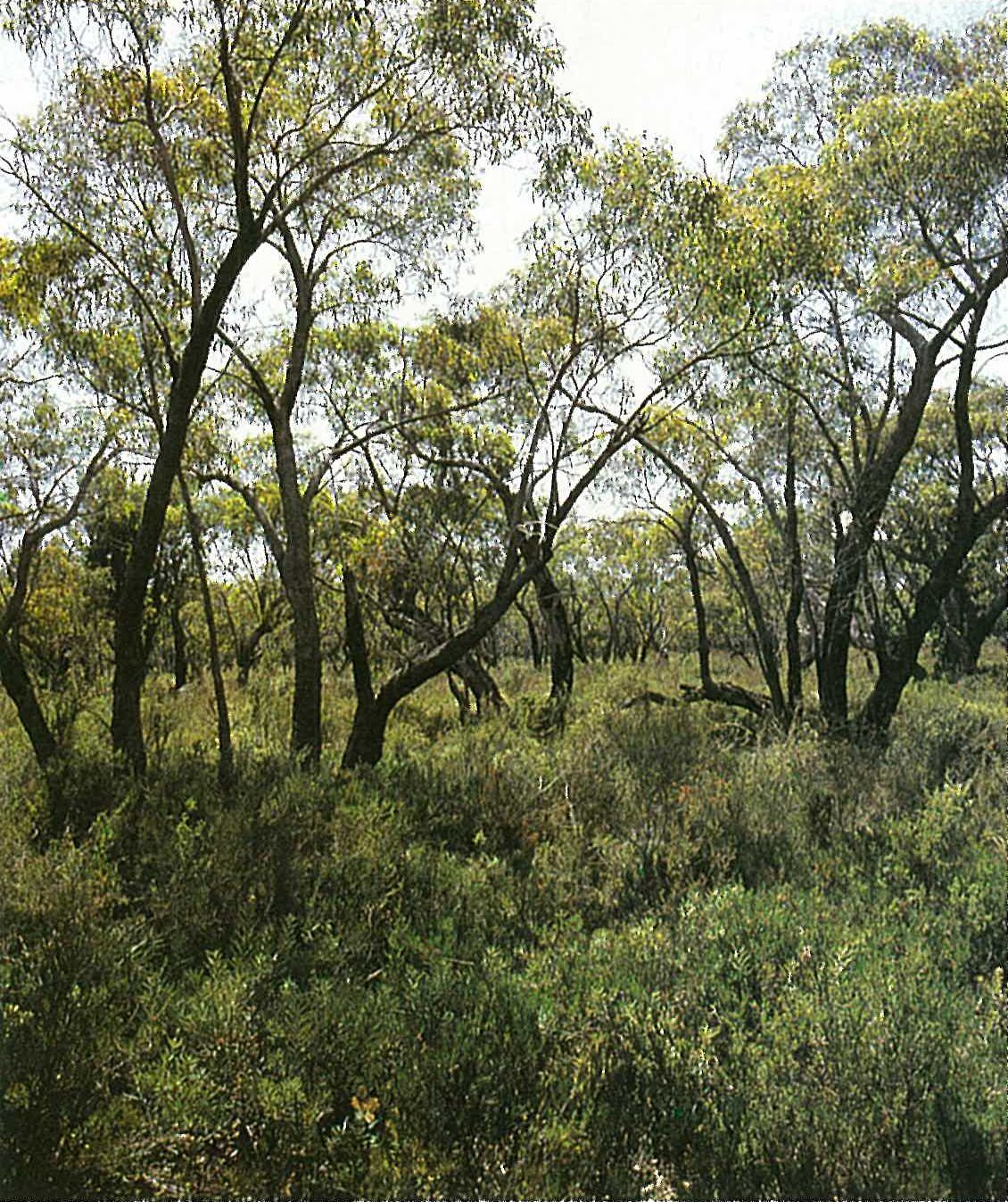
The shrub-layer of this community is always dominated by the dense shrub Leptospermum myrsinoides (Silky Tea-tree). In the more western areas of the region (e.g. Mornington Peninsula) this community often exists without trees, or with only a sparse tree cover, hence varying from a closed-heath to an open-woodland. In the central areas of the Gippsland Plain, the tree-layer is usually well developed and results in a woodland with a heathy understorey on flat to undulating plains, in deep sandy soils (mean annual rainfall 700–900 mm). In the south Eucalyptus pryoriana is the major tree species, in the central region (e.g. Mullungdung and Boodyarn Forests) E. consideniana and E. radiata are the commonest species, and in the north-east (e.g. Holey Plains) E. willisii is the commonest species (Plate 6Z). This community just extends into the Gippsland Highlands. The shrub-layer is dominated by sclerophyllous shrubs (e.g. Acacia oxycedrus, Aotus ericoides, Bossiaea cinerea, Dillwynia glaberrima, Epacris impressa, Gahnia radula, Hibbertia acicularis, Leptospermum continentale, Leucopogon ericoides, L. virgatus, Lomandra longifolia, Monotoca scoparia and Xanthorrhoea minor). In all areas Banksia marginata and/or B. serrata are usually also abundant. Gullan et al. (1984, 1985) and Opie et al. (1984a, 1984b) recognized several subcommunities in the central Gippsland and Westernport Bay areas, respectively. This community is common in the Holey Plains area (south-east of the Strzelecki Ranges), south and west of Sperm Whale Head, the Hastings area and French Island.
Coast Tea-tree scrub
An open- to closedshrubland dominated by Leptospermum laevigatum occurs on coastal (altitude sea-level to 100 metres) calcareous sands (mean annual rainfall 700–1000 mm). The canopy of Leptospermum laevigatum is often so dense that understorey and ground-layer are suppressed. More open subcommunities include Leucopogon parviflorus and Banksia integrifolia as co-dominants. Common species associated with this community include Clematis microphylla, Daucus glochidiatus, Dichondra repens, Isolepis nodosa, Rhagodia candolleana, orchids and Senecio lautus. This community is widespread along the coast of Phillip Island and along the south-west coast of the mainland between Sandy Point and Flinders, and at Sandy Point on French Island. Old stands of very tall plants of Leptospermum laevigatum (c. 10 metres high) occur at Yaringa, Cannons Creek and Chinaman Island (all in Westernport Bay) (Opie et al. 1984a, 1984b).
During the mid-nineteenth century much of the Mornington Peninsula was seriously disturbed by timber-cutters and lime-burners who removed all large trees and scraped much of the surface (Calder, W. 1986). The Allocasuarina verticillata-dominated grassy woodland was largely replaced by Leptospermum laevigatum which spread inland from its normally restricted zone along the shoreline. The resultant community now almost totally excludes Allocasuarina verticillata.
Coastal heathland to open scierophyll woodland
A wet closed-heath to open-woodland occurs on poorly drained sandy or clayey soils, principally of near-coastal areas. The dominant species of this community, Melaleuca squarrosa and Leptospermum continentale, form a dense community and produce a very deep leaf-litter layer. The understorey and ground-layer are very open to scattered. An open-heath to sedgeland occurs on wetter sites, particularly when there is standing water for long periods (e.g. French Island). The generally shaded and waterlogged substrate is most successfully colonized by members of the Restionaceae (e.g. particularly Empodisma minus and Leptocarpus tenax) and Cyperaceae (e.g. Baumea juncea, Gahnia radula, Lepidosperma filiforme, L. longitudinale, L. neesii, Schoenus apogon, S. brevifolius, S. latelaminatus and S. tenuissimus). Scattered examples of this community occur on French Island, at Holey Plains and at Gellions Run (near Alberton). Other common species, particularly on drier sites, include Allocasuarina paludosa, Burchardia umbellata, Caesia parviflora, Centrolepis aristata, Dampiera stricta, Danthonia setacea, Dillwynia glaberrima, Epacris gunnii, E. impressa, Goodenia humilis, Hibbertia procumbens, H. riparia, Leptospermum myrsinoides, Lindsaea linearis, Selaginella uliginosa and Xanthosia pusilla. Eucalyptus kitsoniana occurs on wet solodic soils, whereas E. pryoriana occurs as an overstorey on drier soils (e.g. Gellions Run). ‘Grass-tree plains’ with Xanthorrhoea resinosa dominant, and common in far East Gippsland, are represented by a disjunct western outlier near Gelliondale.
Melaleuca ericifolia scrub
A closed-scrub community dominated by thickets of Melaleuca ericifolia (2–8 metres high) occurs on wet, heavy soils in lowland areas (altitude up to c. 70 metres). This species and Phragmites australis, both opportunistic, commonly occur on roadside verges, drains and damp depressions of disturbed sites. On clay-loam soils in highly disturbed, often pastoral sites, this community is often associated with riparian scrub or grassy woodland communities (e.g. Bittern, Mornington Peninsula, Morwell River, near Morwell, south of the Latrobe River, and west of Traralgon). On the Mornington Peninsula much of the area supporting this community has been drained and converted to pasture. The ground-layer is predominantly composed of introduced herbs (e.g *Cyperus eragrostis, *Hypochoeris radicata, *Myosotis laxa, *Rorippa nasturtiumaquaticum, *Rumex conglomeratus). Melaleuca ericifolia dominates a scrub subcommunity on the poorly drained sands in disturbed near-coastal areas between Port Welshpool and Port Albert (Gullan et al., 1984, 1985) with associated species including Acacia longifolia, A. verticillata, Disphyma crassifolium subsp. clavellatum, Rhagodia candolleana and Senecio lautus. At Gellions Run another subcommunity grows in association with the coastal wet heathland. The species of this subcommunity include Baumea acuta, *Centaurium tenuiflorum, Centella cordifolia, Deyeuxia densa, Gahnia trifida, Gnaphalium (sensu lato) spp., Gonocarpus tetragynus, Goodenia humilis, *Hypochoeris radicata, Lagenifera gracilis, Leptocarpus tenax, Leptospermum continentale, Lobelia alata, Schoenus tesquorum and Selaginella uliginosa. A similar subcommunity, in association with Eucalyptus pryoriana, occurs in the Westernport Bay area (Opie et al. 1984a, 1984b). A closed-scrub sub-community occurs on the poorly drained coastal mudflats that are inland from and associated with the saltmarsh community. These sites are dominated by Melaleuca ericifolia, with the understorey and ground-layer composed of a variety of typical saltmarsh species (e.g. Disphyma crassifolium subsp. clavellatum, Samolus repens and Selliera radicans). This subcommunity is common on the western shoreline of Westernport Bay (Calder 1986; Opie et al. 1984a, 1984b) (Figure 6.20) and on Snake Island (Gullan et al. 1984, 1985).
Melaleuca squarrosa often dominates areas of waterlogged, strongly acidic sandy soils, sometimes with M. ericifolia (e.g. in the Tootgarook Swamp, south-west of Rosebud, and Gellions Run).
Freshwater and saltwater communities
Freshwater marsh
A community of aquatic vegetation occurs in pools of standing water on lowland farming areas (e.g. Gellions Run near Gelliondale, south of the Strzelecki Ranges) and in shallow, still water (e.g. billabongs) near the lower-altitude tributaries of the Morwell River. The most common species include Lemna disperma, Spirodela punctata (both floating on the water surface), Eleocharis sphacelata, Potamogeton spp., Triglochin procerum and Typha spp. (all the latter species being rooted in the substrate).
Sedge swampland
An open-sedgeland community usually occurs on seasonally inundated sites near the wetter parts of coastal heathland. In most cases the vegetation is dominated by one or two sedges that grow in dense swards, often to the exclusion of all other species (e.g. Lepidosperma longitudinale and L. laterale). This community occurs at Gellions Run and Holey Plains. A Schoenus brevifolius-dominated subcommunity occurs near Cranbourne, in association with a Eucalyptus cephalocarpa/E. pryoriana overstorey. Other commonly associated species include Hakea ulicina, Lepidosperma longitudinale, Leptospermum continentale and Lepyrodia muelleri. Slightly drier sites usually support a floristically more diverse subcommunity (e.g. in scattered localities in the north-west of French Island).
Mangrove
A closed-heath or -scrub community consisting entirely of Avicennia marina (White Mangrove) forms a broad zone between the saltmarsh community and the sea (Plate 6a). Meadows of Zostera muelleri frequently occur on the seaward side of the mangroves. The mangroves occupy the zone between high and low tide levels. Hence, this monospecific community is regularly inundated by tidal waters. Avicennia marina is shrub-like, and seldom exceeds heights of 2.5 metres. Usually, the community lacks an understorey, however, occasional saltmarsh species may be present. In Victoria the mangroves are virtually confined to this region, and occur on patches of muddy alluvium along the coast of Corner Inlet (the most southerly occurrence of the species), in Westernport and Port Phillip Bays. The distribution of this community has been significantly reduced since European settlement.
Saltmarsh
An open-shrubland to closed-herbfield community of salt-tolerant, often succulent species occurs on the intertidal mudflats of Corner Inlet and the offshore islands, Westernport and Port Phillip Bays (at sea-level). The community is markedly zoned into a number of recognizable subcommunities, from seaward to landward. The outermost (seaward) zone on mudflats subject to regular inundation is usually made up entirely of Sarcocornia quinqueflora. This subcommunity is immediately landward of the mangrove community. It also occurs along tidal creeks and inland in depressions that accumulate seawater from the higher tides of the year (Opie et al. 1984a, 1984b). The sub-shrub Suaeda australis is often also present, particularly where large amounts of Zostera muelleri and algal Rhizoclonium spp. detritus are washed onto the beach (Bridgewater & Hughes 1974). Other species that are often present include Distichlis distichophylla, Hemichroa pentandra, Samolus repens, Selliera radicans and Triglochin striatum. Landward of the above subcommunities, particularly on areas that have undergone greater mud accretion, is a heathland to low-shrubland that is dominated by, and sometimes made up entirely of, Sclerostegia arbuscula. A number of herbs make up the ground-layer. Species that occur in this association include Hemichroa pentandra, Samolus repens, Sarcocornia quinqueflora, Suaeda australis and Triglochin striatum. Sclerostegia arbuscula-dominated subcommunities often intergrade with those dominated by Sarcocornia quinqueflora (Plate 6a). Atriplex paludosa is often present on drier sites. The driest and more elevated sites support Stipa stipoides, often to the exclusion of Sclerostegia arbuscula. Gahnia filum occurs with Sclerostegia arbuscula when the substrate is too wet for Stipa stipoides. Juncus kraussii may also dominate this zone. Further inland is a closed-herbfield with a mixture of low herbs and semi-shrubs. This subcommunity represents the extreme landward edge of the saltmarsh preceding the Melaleuca ericifolia shrubland. Common species include Agrostis billardieri, Angianthus preissianus, *Cotula coronopifolia, Disphyma crassifolium subsp. clavellatum, Frankenia pauciflora, *Parapholis incurva, Samolus repens, Sarcocornia quinqueflora, Schoenus nitens and Sporobolus virginicus.

Coastal communities
Coastal dune scrub and coastal tussock grassland
These extremely exposed communities consist of grasses, sedges, herbs and salt-pruned shrubs. The calcareous sand of the primary dune open-shrubland alliance is dominated by Acaena novae-zelandiae, Isolepis nodosa and Poa poiformis. Other common species include Dianella revoluta, Geranium spp., *Holcus lanatus, *Hypochoeris radicata, Leucophyta brownii, Oxalis radicosa, Senecio lautus and Tetragonia implexicoma. A tussock grassland alliance is now frequently dominated by the introduced grass *Ammophila arenaria. This has largely replaced the native sand-binding grass Spinifex sericeus. This alliance shares many species with the former. Other common species include Cardamine gunnii, Daucus glochidiatus, Olearia axillaris, Ozothamnus turbinatus, *Polycarpon tetraphyllum and Rhagodia candolleana. Both alliances are easily disturbed, and in many areas have suffered from trampling. These communities are distributed along the length of the Ninety Mile Beach between Sea-spray and Lakes Entrance (Gullan, Walsh & Forbes 1981).
Land use
The coast and the Gippsland Lakes are extensively used for recreation and commercial fishing. The main agricultural industries include dairying, and beef, lamb and wool production. Vegetable (particularly potato) production, is also an important agricultural activity. Relatively low-intensity hardwood production occurs in the region, whereas softwood production is more important. The forests and plantations are principally used for the production of wood-pulp. The brown coal deposits in the Yallourn Valley are a significant energy resource that is mined by open-cut techniques (Anon. 1980b). Off-shore oil and natural gas fields are also a valuable energy resource.
National Parks
- Churchill—193 ha; Morwell—283 ha;
- Point Nepean—2450 ha; The Lakes—2390 ha;
- Wilsons Promontory (Yanakie Isthmus only)—900 ha.
State Parks
- Arthurs Seat—350 ha;
- Corner Inlet Marine and Coastal Park—18 000 ha;
- French Island—8300 ha;
- Gippsland Lakes Coastal Park—17 200 ha;
- Holey Plains—10 576 ha;
- Nooramunga Marine and Coastal Park—15 000 ha;
- Shallow Inlet Marine and Coastal Park—2000 ha.
Source: Conn, B.J. (1993) Natural regions and vegetation of Victoria, in: Foreman, D.B. and N.G. Walsh (eds), Flora of Victoria Volume 1, pp. 79–158, Inkata Press.