Riverina
The Riverina natural region as recognised by Conn (1993) comprises the Victorian Riverina and Murray Fans regions in the current system of bioregions in Victoria.
Location
This region is defined largely on topographical and geological features. However, these features and the vegetation are strongly correlated. The Riverina includes the eastern part of the Murray Basin. The southern and eastern boundary of the region occurs at an elevation of about 150 metres and adjoins the low hills and ranges of the Midlands (Victoria) and South-western Slopes (New South Wales). It extends north to a latitude of about 33°S, including Ivanhoe and Conoble Lake (in New South Wales). The western boundary of this region is the boundary between the aeolian and fluviatile landforms, and associated soils and vegetation. The aeolian landform supports the mallee communities of the Murray Mallee Region.
Major grids G, H, L, M, Q and R. Approximate area 23 864 km2.
Major landforms
The Riverina (‘Riverine Plain’ of Butler et al. 1973) includes the eastern part of the Cainozoic sedimentary Murray Basin. The Murray Basin results from regional subsidence with upwarping of the marine sediments during the Quaternary (Hills 1939). The unconsolidated fluviatile deposits beneath the current riverine plain are between 90 and about 305 metres thick (Butler et al. 1973).
The surface of the riverine plain shows evidence of ancient stream channels (paleochannels) (Butler et al. 1973; Curney & Dole 1978; Macumber 1978). See Bowler (1967) and Pels (1969) for accounts of the prehistory of the region. The modern drainage of the riverine plain forms a tributary system, with most tributaries joining the Murray River before it leaves the plain. Several major streams have smaller streams branching from them. Some of these subsequently rejoin the main stream downstream (e.g. Edward River, New South Wales), whereas others divert the flow from the main tributary system and terminate in lakes, salt pans or dune-fields. Examples of channels that divert water away from the Murray River tributary system include those associated with the Avoca and Loddon Rivers, Victoria (Hills 1940); and the Lachlan River, New South Wales (Mitchell 1839). Shallow, dry lakes (playas) are distributed widely in the region. They are very common in the Avoca–Loddon Rivers area (Victoria) and to the west of the Lachlan River (New South Wales). The dry basins vary according to the salinity of their surfaces. Several saline basins (salinas) occur near Kerang. There are very few permanent lakes with extensive expanses of water. Aeolian-derived landforms occur infrequently in the region. They occur either as lunettes, that are associated with lakes, as sand dunes derived from the sandy deposits of ancient streams, or as scalds (bare areas produced by the removal of the surface soil).
The Riverina consists of several very gently sloping alluvial fans and the floodplains onto which the fans merge. These fans merge to form a single low-gradient fan between the Loddon and Lachlan Rivers.
The soil types of the region vary from grey, brown, to red clays (often of high salinity), and to red-brown earths. The soils of the floodplain areas are grey clays and silty clays, with low salinity. Red and yellow duplex soils are widespread on the older, upper river terraces and fans. For further details refer to Butler (1950); Butler and Hubble (1978); Butler et al. (1973); Rowe, Crouch and van Dijk (1978); and Gibbons and Rowan, this volume.
Climate
The general climatic trend in the region is one of gradation, characterized by increasingly longer and warmer summers from the south-east to the north-west (Anon. 1983). The average annual rainfall decreases from south-east to north-west. The region has a winter maximum rainfall (250–500 mm per annum). The winds are predominantly from the north-west, west and south-west. Frequent north-westerly winds bring with them hot, dry air from central Australia during the summer months. Annual evaporation far exceeds the annual precipitation. Frosts are common and may be severe, and the region is drought-prone (see also ‘Climate of Victoria’, this volume).
Vegetation
Prior to European settlement the natural vegetation consisted of woodlands dominated by Eucalyptus and Callitris. Most of the latter communities have been cleared for agriculture. A summary of the vegetation of this region is based on small scattered remnants and that which occurs on public land (such as State Forests). Insufficient vegetation remains to enable each alliance to be fully circumscribed.
Forests and woodlands
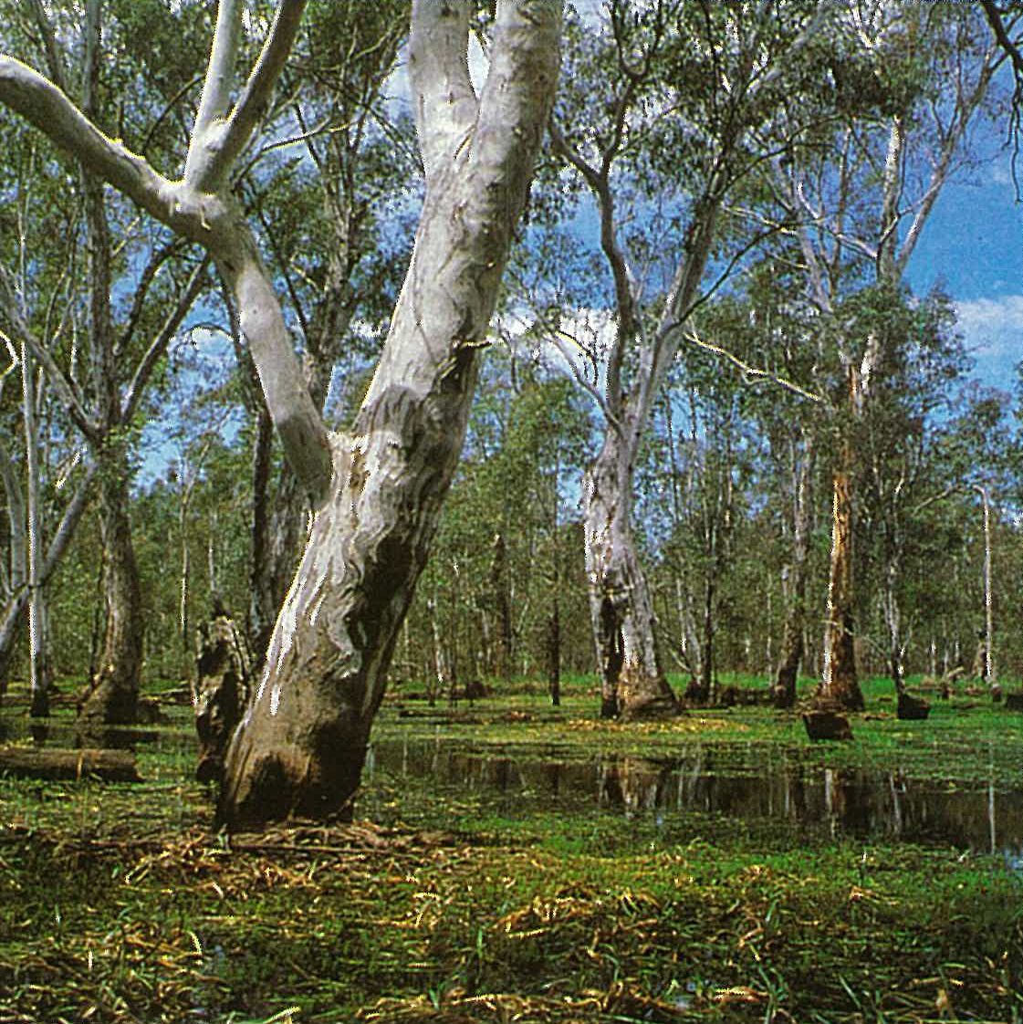
Eucalyptus camaldulensis (River Red-gum)
Eucalyptus camaldulensis occurs as a dominant of open-forest or woodland (28–40 metres high), particularly in areas that receive regular flooding (Dexter 1978). It occurs as a narrow band along the tops of river banks or as woodlands (less frequently as forests) in flooded areas. In this region much of this community occurs on heavy clay soils. Eucalyptus camaldulensis usually forms pure stands, but occasionally it forms ecotonal associations with other watercourse species or with other species that are typical of the neighbouring woodlands (e.g. E. melliodora and E. microcarpa). The understorey is usually sparse, with woody shrubs being localized around watercourses and on sandy ridges within the floodplain forest. An understorey of small trees and saplings of E. camaldulensis may be present. The most widespread shrub is Acacia dealbata. Callistemon sieberi is present along the Ovens River, and Dillwynia cinerascens occurs along the gravelly banks of the Goulburn River. The ground-layer is a mosaic of grass-dominated communities, with rushes (Juncus species), and sedges (Cyperaceae). The common grasses include Agrostis avenacea, *Cynodon dactylon, Danthonia caespitosa, D. duttoniana, D. racemosa, D. setacea, Paspalidium jubiflorum, with Amphibromus nervosus and Pseudoraphis spinescens frequently common on the wetter floodways (Plate 6M). The most common sedges and rushes include Carex tereticaulis and Eleocharis acuta. Several species of Cyperus and Juncus are common. Dicotyledonous herbs are frequently common locally, especially in damp depressions (e.g. Alternanthera denticulata, Brachyscome spp., Calotis spp., Centipeda cunninghamii, Craspedia spp., Crassula helmsii, Gnaphalium (sensu lato) spp., Isotoma fluviatilis, Polygonum spp., Senecio spp. and Stellaria caespitosa). Areas of bare ground are common, and the ground is usually littered with flood-carried debris.
In certain scattered and localized areas (e.g. Barmah and Gunbower State Forest) former grasslands are being colonized by Eucalyptus camaldulensis (Anon. 1983).
A lower E. camaldulensis open-forest (15–28 metres high) occurs on drier sites amongst the taller forest/woodland discussed above. Floristically, these alliances are similar, except that in the lower forest there is an increase in those species that tolerate drier conditions (e.g. Elymus scabrus, Chloris, Danthonia and Stipa spp.) and fewer that prefer wetter conditions (e.g. Pseudoraphis spinescens and other aquatic species). Examples occur on the Broken, Campaspe and Loddon Rivers, around swamps and lakes (e.g. near Boort) and along many minor watercourses.
Periodic flooding is an important, albeit complex factor in seed germination in Eucalyptus camaldulensis. Prolific germination of the seeds occurs following the retreat of floodwaters in spring, but winter water temperatures are generally unfavourable for germination on flooded sites. Dexter (1978) discusses the relationship between the various factors that are important for effective seed germination and seedling establishment for this species.
Eucalyptus largiflorens (Black Box)
Eucalyptus largiflorens-dominated open-forest to woodland (10–28 metres high) occurs on the outer margin of the riverine E. camaldulensis forests (usually in the less frequently inundated areas), along the Murray River as far east as Barmah, and is also associated with some lakes and swamps. It occurs mainly on grey, cracking clay soils that are mostly alkaline. It occurs on moderately saline soils in some parts of the region (particularly in the north-west). These soils support halophytic shrubs and herbs in the understorey. The E. largiflorens community is most abundant in New South Wales (Beadle 1981). This community is composed of either pure stands of E. largiflorens, or occurs in ecotonal association with E. camaldulensis or E. melliodora. The lower strata vary from being shrubby through to having a very open grassy ground-layer. The associated tall shrubs usually form a discontinuous stratum, with the most common ones being Senna spp. and Muehlenbeckia florulenta. Other shrubs that may be locally common include species of Acacia, Exocarpos and Myoporum. The dominant grasses include species of Danthonia and Stipa Other common grasses include Agrostis avenacea, *Critesion hystrix and Homopholis proluta. Several halophytic plants are common, particularly in the north-western parts of the region. These include species of Atriplex, Einadia, Enchylaena and Rhagodia, plus Salsola kali. Other common ground-layer herbs include Chamaesyce drummondii, Lythrum spp., Marsilea drummondii (in moister areas), Solanum esuriale and Vittadinia spp.
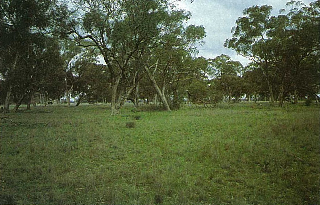
Eucalyptus microcarpa (Grey Box)
Eucalyptus microcarpa-dominated open-forest or woodland (mostly 15–28 metres high) originally covered extensive areas of the plains, but now generally occurs as small remnants. E. microcarpa may occur as pure stands or in association with E. melliodora. E. camaldulensis may also be present. Allocasuarina luehmannii is a common associate, especially on the plains, whereas Eucalyptus blakelyi and E. macrorhyncha (the latter usually on better-drained sites) are restricted associates (e.g. at Killawarra). The understorey is usually sparse, and commonly consists of Acacia acinacea, A. pycnantha, Bursaria spp., Cassinia arcuata and Eutaxia microphylla. The major under-shrubs include Atriplex semibaccata, Enchylaena spp., Maireana spp., Einadia hastata, E. nutans and Sida corrugata. The ground-layer is dominated by grasses (e.g. Agrostis avenacea, Aristida spp., Danthonia caespitosa, D. duttoniana, D. linkii, D. pilosa, D. racemosa, D. setacea, Elymus scabrus, Poa spp., Stipa spp. and Themeda triandra). Species of introduced grasses are common (e.g. *Bromus, *Critesion, **Cynodon, *Lolium and *Phalaris) (Plate 6N).
This community also occurs on the drier margin and the internal sand-ridges of the riverine forests (Anon. 1983), and on the undulating areas near Rutherglen and Killawarra (in the east of the region). Taller stands of this community occur in the higher-rainfall areas, in the eastern parts of the region.
Eucalyptus melliodora (Yellow Box)
This community is very similar structurally and floristically to the Eucalyptus microcarpa-dominated forest and woodland. Eucalyptus melliodora tends to replace E. microcarpa in some hillier areas (e.g. Mount Major) and on sand-ridges (e.g. near Cobram) (Anon. 1983). Both communities have similar associated species. Eucalyptus blakelyi is frequently a co-dominant, and the resultant alliance forms mosaics with the E. albens community, with the former occurring mainly on the river plains, the latter on the adjacent undulating country and extending into the adjacent Midlands Region. Callitris glaucophylla is commonly associated with the Eucalyptus melliodora community, especially on sandy soils. Eucalyptus melliodora tends to grow to a height of 15–20 metres. A taller open-forest community (up to 30 metres high) occurs in the higher-rainfall eastern parts of the region.
Eucalyptus blakelyi (Blakelys Red-gum)
Eucalyptus blakelyi forms a woodland (5–15 metres high) to open-forest (up to about 30 metres high), with the latter occurring on more favourable sites. It occurs as pure stands or in association with E. goniocalyx, E. macrorhyncha, E. melliodora, E. microcarpa and E. polyanthemos (e.g. in the Rutherglen–Wodonga area). Much of the understorey of this community has been replaced by agricultural grasses or crops. Less disturbed examples of this community occur in the neighbouring Midlands Region.
Callitris glaucophylla (White Cypress-pine)
This woodland (10–15 metres high) was once widespread across the plains of this region. It usually occurred as a subdominant to Eucalyptus microcarpa or E. melliodora and Allocasuarina luehmannii. It occurs with both Eucalyptus melliodora and E. microcarpa in the Terrick Terrick State Forest (south-east of Pyramid Hill) on granite-derived soils; in other areas it occurs on sandy soils (with E. melliodora). Callitris preissii also occurs in the Terrick Terrick State Forest. The understorey is either absent or is a sparse, open grassland with sub-shrubs between the tussocks. Depending on the site, this community is floristically similar to the woodlands dominated by Eucalyptus blakelyi, E. melliodora or E. microcarpa.
Swamp and marsh communities
The effects of water regulation, raised saline water-tables, and general agricultural practices have greatly modified the aquatic and semi-aquatic communities of the region. Three major subcommunities are recognized (Anon., 1983).
Lignum swamps
At the time of European settlement, communities dominated by Muehlenbeckia florulenta were a feature of drainage channels and swamps of ‘treeless’ plains (Anon. 1983). The present distribution of Lignum largely reflects land-use patterns. The effects of water regulation and increases in the soil salinity have altered the distribution of this species. M. florulenta forms a more or less globular, tangled shrub (to a height of 2–3 metres), and may form an almost impenetrable thicket. This community depends on regular flooding and a deep penetration of water, hence it occurs in depressions and along drainage lines, mainly in the western parts of the region. It usually occurs on stiff grey to black clay, mostly slightly alkaline soils. Although trees are usually sparse, Eucalyptus largiflorens and, to a lesser extent, E. camaldulensis are often associated with these swamp communities. Chenopodium nitrariaceum is commonly associated with Lignum. The common grasses include Agrostis avenacea, Danthonia spp. and Stipa spp. The other sub-shrubs and herbs are similar to those found in the Eucalyptus largiflorens-dominated open-forest/woodland (see above).
Halophytic shrublands
As for the Lignum swamps, the present distribution and floristic structure of the halophytic shrublands largely reflect current land-use practices. The area of land affected by surface salt has increased greatly since European settlement (Anon. 1983). Species of the Chenopodiaceae and Aizoaceae are the most common representatives of these shrublands (e.g. *Galenia pubescens, Halosarcia spp., Maireana spp., Salsola kali, Sclerostegia tenuis and Suaeda spp.). Other common species include Muehlenbeckia florulenta and Stipa spp. The density and composition of the community is influenced by soil salinity levels. This community occurs most extensively in the western part of the region.
Rush and sedgeland swamps
A tall (up to 2 metres high) closed-grassland/sedgeland occurs in more or less permanent shallow water. This subcommunity is often dominated by Typha spp. and/or Phragmites australis. Typha spp. (e.g. T. domingensis) occurs in shallow water near the banks of rivers, in billabongs, farm dams, irrigation channels (often as a serious weed) and in ‘delta swamps’ (Beadle 1981). Juncus ingens forms extensive stands at Top Island (in the Barmah State Forest) and Lake Moodemere (both on the Murray River). A range of aquatic and semi-aquatic species are associated with these grassland/sedgelands, particularly in more open situations (e.g. species of Azolla, Cyperus, Eleocharis, Juncus, Lemna, Potamogeton and Triglochin, and Ludwigia peploides and Ottelia ovalifolia).
Grasslands
Prior to European settlement, large areas of this region supported indigenous grasslands that were either treeless or sparsely wooded. Most of this community was quickly alienated for agriculture (Anon. 1983). Only scattered remnants remain, and these have been usually greatly modified by grazing, rabbits, and weed invasion. It is assumed that these grasslands were dominated by species of Danthonia and Stipa. Grasslands also occur in areas where inundation prevents tree growth, mainly in the riverine zone. The common grasses include Amphibromus nervosus, *Cynodon dactylon, Eragrostis spp. and Pseudoraphis spinescens. Other herbaceous genera that are commonly present include Alternanthera, Carex, Centipeda and Dysphania.
Land use
The region has been extensively cleared for the cultivation of cereal crops (mainly wheat, barley and oats), livestock grazing (sheep and cattle), vineyards and orchards (the latter two occur in irrigated areas). Utilization of Eucalyptus camaldulensis for firewood, fencing, railway sleepers and harbour construction has a long history (Anon. 1983). Callitris glaucophylla has been used for house construction because it is termite-resistant. Other eucalypt species have been used for fencing and firewood. Since settlement, the utilization of timber has been mainly restricted to that which grows on public lands.
Considerable changes affecting the land and the drainage patterns have occurred since European settlement. Initially, the natural vegetation was selectively depleted by grazing pressure. In the late 1880s rabbit infestations further aggravated soil erosion and pasture depletion. Large-scale irrigation schemes for the production of fodder crops, cereals, and fruit were established by 1890 on the Campaspe, Goulburn and Loddon Rivers (Butler et al. 1973). Problems of salinity and waterlogging were evident soon after irrigation began (as early as about 1910 in the Kerang area). Irrigation activities have resulted in increased salinity levels in the Murray River due to increased salt returns from the salinization of surface soils (Collett 1978).
The various waterways are important recreational resources that are used for water-based activities (such as canoeing, shooting, swimming, water-skiing, fishing, and bird-watching). An interesting summary of the vegetation, and associated birds and mammals, for the Barmah State Forest, has been provided by Chesterfield et al. (1983). Camping and bushwalking are also important outdoor activities. Many areas along the Murray River are intensively used for recreational purposes. Two such areas are the Barmah and the Gunbower State Forests (both provide breeding habitats for many birds and mammals). Similarly, the other major rivers are intensively used for recreation.
National Parks
There are none in the region.
State Parks
- Barmah—7900 ha; Leaghur—1580 ha.
Source: Conn, B.J. (1993) Natural regions and vegetation of Victoria, in: Foreman, D.B. and N.G. Walsh (eds), Flora of Victoria Volume 1, pp. 79–158, Inkata Press.