Specify to Darwin Core mapping
The National Herbarium of Victoria (MEL), like other Australian herbaria, used to deliver data to the Australasian Virtual Herbarium (AVH) as ABCD 2.06 through a BioCASe provider. The table structure that fed the BioCASe provider was created using a PHP application that has become very hard to maintain.
The Atlas of Living Australia (ALA), which has been hosting the AVH since 2012, has never accepted ABCD, so for the last eight years MEL has been harvesting the BioCASe providers of other Australian herbaria as well and has been transforming ABCD to Darwin Core, which was then delivered as deltas in Darwin Core Archives to ALA.
When the deltas became a problem for ALA – or we finally realised they were a problem – MEL has started weekly delivery of the full AVH data set of 5M records to ALA through the GBIF Integrated Publishing Toolkit (IPT). At that time, early 2019, it was decided that we would phase out the BioCASe providers and that all Australian herbaria should prepare to deliver their own data as Darwin Core Archives directly to ALA.
The biggest barrier for MEL to export data from our collections database directly as Darwin Core was that the MEL AVH data set in ALA also contained the data that was harvested from other Australian herbaria's BioCASe providers and that some herbaria will keep depending on MEL harvesting their BioCASe providers longer than others. So we have had a Darwin Core mapping for over a year without being able to use it.
Over the first half of 2020 the MEL AVH data resource in ALA was split into individual data resources for each herbarium (which was not nearly as easy as it sounds). This opened the way for MEL to start exporting data from its Specify database directly as Darwin Core into an IPT using the Schema Mapper and Data Exporter tool that are available in Specify.
Preparing the schema
Because Darwin Core has been updated since we first set up our database about
ten years ago, I had to import the latest Darwin Core Schema. The Darwin Core
schema is missing the record level terms that are borrowed from Dublin Core. We
only need modified, as the other Dublin Core terms that we use have standard
values for the entire data set.
I added modified to the schema like so:
INSERT INTO spexportschemaitem (TimestampCreated, TimestampModified, Version,
    CreatedByAgentID, DataType, FieldName, SpExportSchemaID)
VALUES (now(), now(), 0, 1, 'xs:dateTimeIso', 'modified', 14);
Also, the collecting date is stored in Specify as StartDate and EndDate,
the Darwin Core eventDate is an ISO 8601 date string with the start and end
date separated by a slash ('/'). Therefore, if there is an end date (I
discovered that almost 4,000 of our records have one), it can not be mapped
correctly to eventDate. I have "resolved" this by adding eventDateStart
and eventDateEnd to the schema.
INSERT INTO spexportschemaitem (TimestampCreated, TimestampModified, Version,
    CreatedByAgentID, DataType, FieldName, SpExportSchemaID)
VALUES (now(), now(), 0, 1, 'xs:dateTimeIso', 'eventDateStart', 14),
    (now(), now(), 0, 1, 'xs:dateTimeIso', 'eventDateEnd', 14);
eventDateStart and eventDateEnd will be concatenated into eventDate in the
query that feeds the IPT.
Pre-processing
For many terms there is no straight mapping from the Specify data model – or at least the implementation at the National Herbarium of Victoria – to Darwin Core terms, so some pre-processing of data is necessary.
I have tried to do this as much as possible in SQL, which can be stored in the database as functions and stored procedures, but for some of the Location terms the processing needed went beyond what I can do in MySQL, so I have used a bit of Python as well.
Record Level Terms

Occurrence
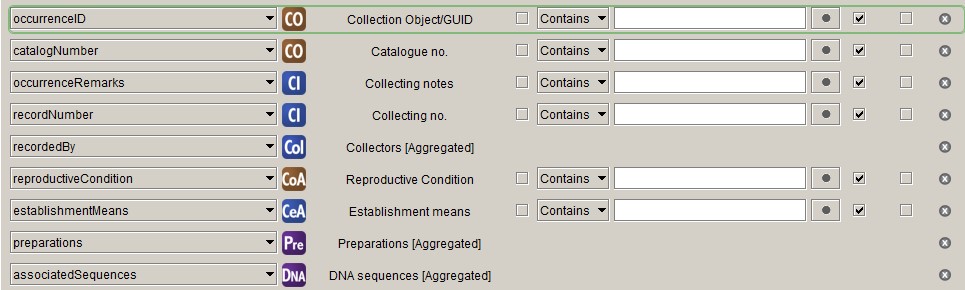
reproductiveCondition
We map what we call "Phenology" in the herbarium community to
reproductiveCondition in Darwin Core, which is not ideal but the best we can
do at the moment. Phenology in the herbarium world is mainly the presence of
certain reproductive structures on specimens. We use five fields in the
Collection Object Attribute
table to record a selection of terms from the
HISPID vocabulary:
flowers, fruit, buds, fertile and sterile. These values need to be concatenated
into a string.
DELIMITER $$

DROP FUNCTION IF EXISTS `dwc_reproductive_condition` $$
CREATE FUNCTION `dwc_reproductive_condition`(in_collection_object_id INT)
RETURNS varchar(128) CHARSET utf8
BEGIN
	declare var_flower varchar(8);
	declare var_fruit varchar(8);
	declare var_buds varchar(8);
	declare var_fertile varchar(8);
	declare var_sterile varchar(8);
    declare out_reproductive_condition varchar(128);

	SELECT coa.Text13, coa.Text14, coa.Text15, coa.Text17, coa.Text18
    INTO var_flower, var_fruit, var_buds, var_fertile, var_sterile
	FROM collectionobjectattribute coa
	JOIN collectionobject co ON coa.CollectionObjectAttributeID=co.CollectionObjectAttributeID
    WHERE co.CollectionObjectID=in_collection_object_id;

    SET out_reproductive_condition=NULL;
    IF var_flower='1' OR var_fruit='1' OR var_buds='1' THEN
        IF var_flower='1' THEN
            SET out_reproductive_condition='flowers';
        END IF;
        IF var_fruit='1' THEN
			IF out_reproductive_condition IS NOT NULL THEN
                SET out_reproductive_condition = CONCAT_WS('|', out_reproductive_condition, 'fruit');
			ELSE
				SET out_reproductive_condition = 'fruit';
            END IF;
        END IF;
        IF var_buds='1' THEN
			IF out_reproductive_condition IS NOT NULL THEN
                SET out_reproductive_condition = CONCAT_WS('|', out_reproductive_condition, 'buds');
			ELSE
				SET out_reproductive_condition = 'buds';
            END IF;
        END IF;
	ELSEIF var_fertile='1' OR var_sterile='1' THEN
		IF var_fertile='1' THEN
			SET out_reproductive_condition='fertile';
		ELSEIF var_sterile='1' THEN
			SET out_reproductive_condition='sterile';
		END IF;
    END IF;

RETURN out_reproductive_condition;
END$$
DELIMITER ;
The resulting value is stored in the Text28 field in the Collection Object
Attribute table.
DELIMITER $$

DROP PROCEDURE IF EXISTS `update_dwc_reproductive_condition`$$
CREATE PROCEDURE `update_dwc_reproductive_condition`()
BEGIN
	UPDATE collectionobjectattribute coa
    JOIN collectionobject co ON coa.CollectionObjectAttributeID=co.CollectionObjectAttributeID
    SET coa.Text28=dwc_reproductive_condition(co.CollectionObjectID);
END$$
DELIMITER ;
establishmentMeans
We still record what is called establishmentMeans in Darwin Core in the way
HISPID used to recommend and have two fields, Introduced status (Text11)
and Cultivated status (Text13), in the
Collecting Event Attribute
table. We should probably adopt the Darwin Core recommendation, as that is what
we do in our flora, but for now we need to convert the content of the two fields
we have to the correct Darwin Core establishmentMeans values. The following
function does just that:
DROP function IF EXISTS `dwc_establishment_means`;

DELIMITER $$
CREATE FUNCTION `dwc_establishment_means`(in_collection_object_id INT)
RETURNS varchar(50) CHARSET utf8
BEGIN
    DECLARE var_introduced varchar(50);
    DECLARE var_cultivated varchar(50);
    DECLARE out_establishment_means varchar(50);

    SELECT cea.text11, cea.text13
    INTO var_introduced, var_cultivated
    FROM collectionobject co
    JOIN collectingevent ce ON co. CollectingEventID=ce.CollectingEventID
    JOIN collectingeventattribute cea ON ce.CollectingEventAttributeID=cea.CollectingEventAttributeID
    WHERE co.CollectionObjectID=in_collection_object_id;

    SET out_establishment_means = NULL;
    IF var_introduced = 'Native' THEN
        SET out_establishment_means = 'native';
	ELSE
        IF var_introduced = 'Not native' THEN
            SET out_establishment_means = 'introduced';
		END IF;
	END IF;

    IF var_cultivated='Cultivated' THEN
        SET out_establishment_means = 'cultivated';
	END IF;

RETURN out_establishment_means;
END$$
DELIMITER ;
The resulting value is stored in Text7 in the Collecting Event Attribute
table.
DELIMITER $$

DROP PROCEDURE IF EXISTS `update_dwc_establishment_means`$$
CREATE PROCEDURE `update_dwc_establishment_means`()
BEGIN
    UPDATE collectingeventattribute cea
    JOIN collectingevent ce ON cea.CollectingEventAttributeID=ce.CollectingEventAttributeID
    JOIN collectionobject co ON ce.CollectingEventID=co.CollectingEventID
    SET cea.Text7=NULL
    WHERE co.CollectionID=4;

    UPDATE collectingeventattribute cea
    JOIN collectingevent ce ON cea.CollectingEventAttributeID=ce.CollectingEventAttributeID
    JOIN collectionobject co ON ce.CollectingEventID=co.CollectingEventID
    SET cea.Text7=dwc_establishment_means(co.CollectionObjectID)
    WHERE co.CollectionID=4 AND (cea.Text11 IS NOT NULL OR cea.Text13 IS NOT NULL);
END$$
DELIMITER ;
Event
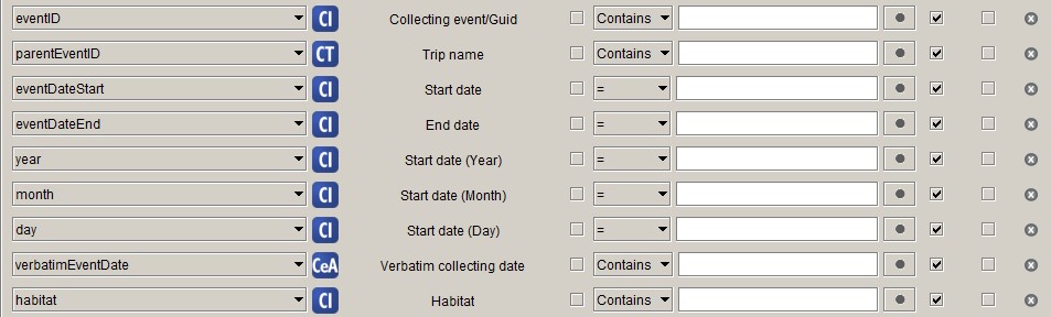
No pre-processing is necessary for any of the properties of the Event class.
I concatenate eventDateStart and eventDateEnd into eventDate, fix up
eventDate for incomplete dates and add startDayOfYear in post-processing.
Location
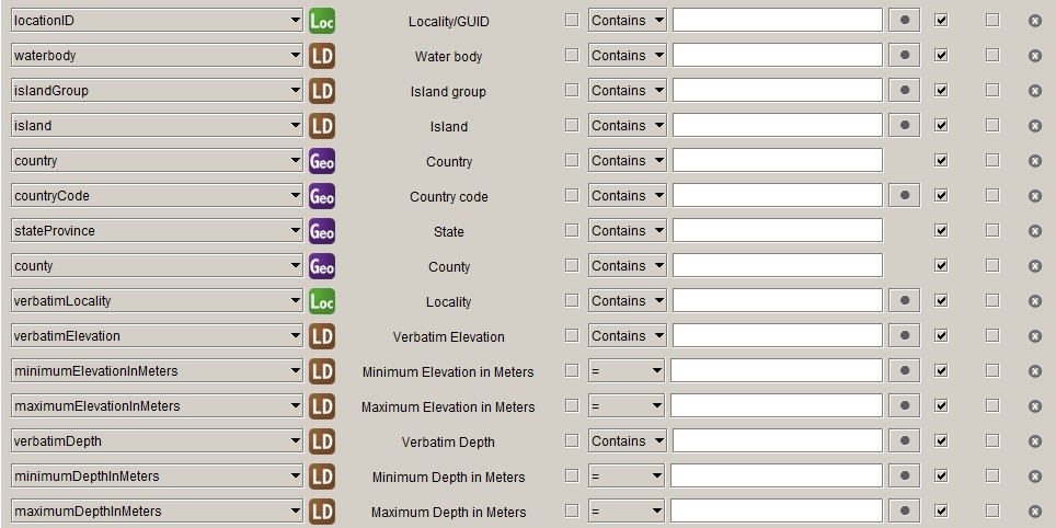
countryCode
The Specify Geography table has a GeographyCode column that has the
countryCode filled in for countries, but has different values or no value for
administrative areas within a country. Therefore, if you map the Specify
GeographyCode to the Darwin Core countryCode, you will end up with mostly
NULL values.
The following function obtains the countryCode for administrative areas within
countries:
DROP function IF EXISTS `dwc_countrycode`;

DELIMITER $$

CREATE FUNCTION `dwc_countrycode` (in_geography_id INTEGER)
RETURNS VARCHAR(32)
BEGIN
    DECLARE var_node_number INTEGER;
    DECLARE var_country_code VARCHAR(32);

    SELECT NodeNumber
    INTO var_node_number
    FROM geography
    WHERE GeographyID=in_geography_id;

    SELECT GeographyCode
    INTO var_country_code
    FROM geography
    WHERE NodeNumber<=var_node_number AND HighestChildNodeNumber>=var_node_number AND RankID=200
    LIMIT 1;

RETURN var_country_code;
END$$

DELIMITER ;
And this procedure stores the value in Text1 in the Geography table:
DELIMITER $$

DROP PROCEDURE IF EXISTS `update_dwc_countrycode`$$
CREATE PROCEDURE `update_dwc_countrycode`()
BEGIN
    UPDATE geography
    SET Text1=dwc_countrycode(GeographyID)
    WHERE GeographyTreeDefID=1 AND RankID>=200;
END$$

DELIMITER ;
This has to be done only once and after that can be manually filled in when new areas are added to the database (a very infrequent event for us).
minimumElevationInMeters, maximumElevationInMeters, verbatimElevation
In Specify you can store altitude in different units and we make use use of
that, as we have many historical collections with altitudes given in feet, so we
have altitudes in metres and feet. Darwin Core only accepts altitude in metres,
so we have to convert the ones in feet. We want to deliver the original values
in feet as verbatimElevation, but do not want to overwrite the verbatim
altitudes we already have. Therefore, we need fields for
minimumElevationInMeters, maximumElevationInMeters and verbatimElevation.
I have put them in Number1, Number2 and Text3 in the
Locality Detail
table.
DELIMITER $$

DROP PROCEDURE IF EXISTS `update_dwc_elevation_terms`$$
CREATE PROCEDURE `update_dwc_elevation_terms`()
BEGIN
    START TRANSACTION;

    UPDATE locality l
    JOIN localitydetail ld ON l.LocalityID=ld.LocalityID
    SET
      ld.Number1 = CASE l.Text1 WHEN 'ft' THEN round(l.MinElevation * 0.3048) ELSE l.MinElevation END,
      ld.Number2 = CASE
        WHEN l.MaxElevation Is Null THEN
              CASE l.Text1 WHEN 'ft' THEN round(l.MinElevation * 0.3048) ELSE l.MinElevation END
            ELSE
              CASE l.Text1 WHEN 'ft' THEN round(l.MaxElevation * 0.3048) ELSE l.MaxElevation END
      END,
      ld.Text3 = CASE
        WHEN l.VerbatimElevation IS NOT NULL THEN l.VerbatimElevation
        ELSE
              CASE l.Text1
            WHEN 'ft' THEN CASE WHEN l.MaxElevation IS NULL THEN CONCAT_WS(' ', l.MinElevation, l.Text1) ELSE CONCAT(l.MinElevation, '–', l.MaxElevation, ' ', l.Text1) END
                ELSE NULL
              END
      END
    WHERE l.MinElevation IS NOT NULL;

    INSERT INTO localitydetail (TimestampCreated, TimestampModified, Version, CreatedByAgentID, LocalityID, Number1, Number2, Text3)
    SELECT now(), now(), 0, 1, l.LocalityID,
    CASE l.Text1 WHEN 'ft' THEN round(l.MinElevation * 0.3048) ELSE l.MinElevation END as minimumElevationInMeters,
    CASE
      WHEN l.MaxElevation Is Null THEN
        CASE l.Text1 WHEN 'ft' THEN round(l.MinElevation * 0.3048) ELSE l.MinElevation END
      ELSE
        CASE l.Text1 WHEN 'ft' THEN round(l.MaxElevation * 0.3048) ELSE l.MaxElevation END
      END AS maximumElevationInMeters,
    CASE
      WHEN l.VerbatimElevation IS NOT NULL THEN l.VerbatimElevation
      ELSE
        CASE l.Text1
          WHEN 'ft' THEN
            CASE
              WHEN l.MaxElevation IS NULL THEN CONCAT_WS(' ', l.MinElevation, l.Text1)
              ELSE CONCAT(l.MinElevation, '–', l.MaxElevation, ' ', l.Text1)
            END
          ELSE NULL
        END
    END AS VerbatimElevation
    FROM locality l
    LEFT JOIN localitydetail ld ON l.LocalityID=ld.LocalityID
    WHERE l.MinElevation IS NOT NULL AND ld.LocalityDetailID IS NULL;

    UPDATE locality l
    JOIN localitydetail ld ON l.LocalityID=ld.LocalityID
    SET ld.Number1=NULL, ld.Number2=NULL, ld.Text3=NULL
    WHERE l.MinElevation IS NULL AND ld.Number1 IS NOT NULL;

    COMMIT;
END$$
DELIMITER ;
minimumDepthInMeters, maximumDepthInMeters, verbatimDepth
The situation with the depth fields is like that for the altitude fields, only
there is an extra unit, fathoms, and the depth field are already in the
Locality detail table, so it is an easier procedure. I have put
minimumDepthInMeters, maximumDepthInMeters and verbatimDepth in Number3,
Number4 and Text4 respectively.
DELIMITER $$

DROP PROCEDURE IF EXISTS `update_dwc_depth_terms`$$
CREATE PROCEDURE `update_dwc_depth_terms`()
BEGIN
    START TRANSACTION;

    UPDATE localitydetail
    SET
      Number3 = CASE StartDepthUnit WHEN '1' THEN StartDepth WHEN '2' THEN ROUND(StartDepth * 0.3048) WHEN '3' THEN ROUND(StartDepth * 1.8288) END,
      Number4 = CASE
        WHEN EndDepth IS NULL THEN
          CASE StartDepthUnit WHEN '1' THEN StartDepth WHEN '2' THEN ROUND(StartDepth * 0.3048) WHEN '3' THEN ROUND(StartDepth * 1.8288) END
            ELSE
              CASE StartDepthUnit WHEN '1' THEN EndDepth WHEN '2' THEN ROUND(EndDepth * 0.3048) WHEN '3' THEN ROUND(EndDepth * 1.8288) END
      END,
      Text4 = CASE
        WHEN EndDepth IS NULL THEN
          CASE StartDepthUnit
            WHEN '2' THEN CONCAT(StartDepth, ' ft')
            WHEN '3' THEN CONCAT(StartDepth, ' fathoms')
                ELSE NULL
              END
            ELSE
          CASE StartDepthUnit
            WHEN '2' THEN CONCAT(StartDepth, '–', EndDepth, ' ft')
            WHEN '3' THEN CONCAT(StartDepth, '–', ENDDepth, ' fathoms')
                ELSE NULL
              END
      END
    WHERE StartDepth IS NOT NULL;

    UPDATE localitydetail
    SET Number3=NULL, Number4=NULL, Text4=null
    WHERE StartDepth IS NULL AND Number3 IS NOT NULL;

    COMMIT;
END$$
DELIMITER ;
Geo-reference
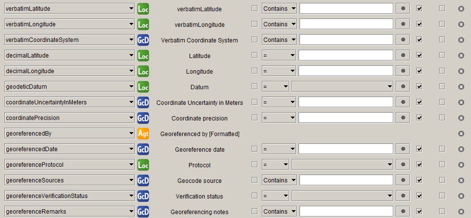
Geo-reference data is in the Location class in Darwin Core, but the class has too many properties to fit in a single screenshot and Specify has a separate table for at least some of the geo-reference related properties.
coordinateUncertaintyInMeters
We – and some other Australian herbaria – have traditionally used a – now seeming rather crude – rank system to record coordinate uncertainty:
- 1: < 50 m
- 2: 50–1000 m
- 3: 1000–10000 m
- 4: 10000–25000 m
- 5: > 25000 m.
For modern collections (as in specimens) it is possible to get much more accurate
uncertainties. We have not quite worked out how to do that well, but we already
have the values that GeoLocate stores in the MaxUncertaintyEst fields that we
would like to deliver in preference to what we have been delivering before (the
upper limit of the classes mentioned above).
The following function returns the upper limit of the given uncertainty class:
DROP function IF EXISTS `coordinate_uncertainty_in_meters`;

DELIMITER $$

CREATE FUNCTION `coordinate_uncertainty_in_meters`(in_precision varchar(2))
RETURNS int(11)
BEGIN
	DECLARE out_uncertainty INTEGER;
    SET out_uncertainty = CASE in_precision
      WHEN '1' THEN 50
      WHEN '2' THEN 1000
      WHEN '3' THEN 10000
      WHEN '4' THEN 25000
      ELSE NULL
	END;
RETURN out_uncertainty;
END$$

DELIMITER ;
Specify has a GeoRefAccuracy field, which I think fits the bill. The following
procedure will store the value of MaxUncertaintyEst if it's there and
otherwise the returned value of the function above in that field. As the
Uncertainty (OriginalElevationUnit) field is in the Locality table and
we will have it for locality records that do not yet have a Geo-coord.
Detail record, new Geo-coord. Detail records will need to be created for
those records.
DROP procedure IF EXISTS `update_coordinate_uncertainty_in_meters`;

DELIMITER $$

CREATE PROCEDURE `update_coordinate_uncertainty_in_meters` ()
BEGIN
	START TRANSACTION;

	UPDATE locality l
	JOIN geocoorddetail gc ON l.LocalityID=gc.LocalityID
	SET gc.GeoRefAccuracy=if(gc.MaxUncertaintyEst IS NOT NULL, ROUND(gc.MaxUncertaintyEst), coordinate_uncertainty_in_meters(l.OriginalElevationUnit))
	WHERE (l.OriginalElevationUnit IS NOT NULL OR gc.MaxUncertaintyEst IS NOT NULL) AND (l.Latitude1 IS NOT NULL AND l.Longitude1 IS NOT NULL);

	INSERT INTO geocoorddetail (TimestampCreated, TimestampModified, Version, CreatedByAgentID, GeoRefAccuracy)
	SELECT now(), now(), 0, 1,
	  coordinate_uncertainty_in_meters(l.OriginalElevationUnit) as geoRefAccuracy
	FROM locality l
	LEFT JOIN geocoorddetail gc ON l.LocalityID=gc.LocalityID
	WHERE (l.OriginalElevationUnit IS NOT NULL AND l.Latitude1 IS NOT NULL AND l.Longitude1 IS NOT NULL) AND gc.GeoCoordDetailID IS NULL;

	COMMIT;
END$$

DELIMITER ;
verbatimCoordinateSystem and coordinatePrecision
I used to derive verbatimCoordinateSystem from the OriginalLatLongUnit field
in the Locality table, but, since we started using Specify 7 we have been
finding some incorrect values for OriginalLatLongUnit, so, for the moment,
I infer verbatimCoordinateSystem myself from the Lat1Text and Long1Text
fields. The obtained value is stored in the OriginalCoordSystem field in the
Geo-coord. Detail table.
Specify does not have coordinatePrecision, so it is calculated from the
Lat1Text and Long1Text fields. ALA has a (rather senseless) data quality
test that fails when the number of decimals of the coordinatePrecision is
different from that of decimalLatitude and decimalLongitude, so we need a
field of type Decimal with 10 digits – because that is what Latitude1 and
Longitude1 have – to store the value. We are using NamedPlaceExtent in the
Geo-coord. Detail table, which fits the bill and was not used before, but it
would be good to have a dedicated field for coordinatePrecision.
The Python code below calculates verbatimCoordinateSystem and
coordinatePrecision. As for the calculation of both terms Lat1Text and
Long1Text need to be parsed into degrees, minutes and seconds, which takes up
about half of the code, the two terms are taken together here.
#!/usr/bin/env python3

import re

def verbatim_coord_system(lattext, lngtext):
    verbatim_coordinate_system = None
    lat_deg, lat_min, lat_sec, lng_deg, lng_min, lng_sec = parse_latlng_text(lattext, lngtext)

    if lat_sec or lng_sec:
        verbatim_coordinate_system = 'degrees minutes decimal seconds'
    elif lat_min or lng_min:
        verbatim_coordinate_system = 'degrees decimal minutes'
    elif float(lat_deg)>0 or float(lng_deg)>0:
        verbatim_coordinate_system = 'decimal degrees'

    return verbatim_coordinate_system

def coordinate_precision(lattext, lngtext):
    coordinate_precision = None
    lat_deg, lat_min, lat_sec, lng_deg, lng_min, lng_sec = parse_latlng_text(lattext, lngtext)

    if lat_sec and lng_sec:
        coordinate_precision = 1 / (60 * 60 * decimal_precision_latlng(lat_sec, lng_sec))
    elif lat_min and lng_min:
        coordinate_precision = 1 / (60 * decimal_precision_latlng(lat_min, lng_min))
    elif float(lat_deg)>0 or float(lng_deg)>0:
        coordinate_precision = 1 / decimal_precision_latlng(lat_deg, lng_deg)

    return coordinate_precision

def parse_latlng_text(lattext, lngtext):
    lat_pattern = r"^([-+]?\d*\.?\d*)?[d°]? ?(\d*\.?\d*)?'? ?(\d*\.?\d*)?\"? ?([NS]{1})?$"
    lng_pattern = r"^([-+]?\d*\.?\d*)?[d°]? ?(\d*\.?\d*)?'? ?(\d*\.?\d*)?\"? ?([EW]{1})?$"

    lat_deg = None
    lat_min = None
    lat_sec = None
    lng_deg = None
    lng_min = None
    lng_sec = None

    lat_match = re.search(lat_pattern, lattext)
    if lat_match:
        lat_deg = lat_match.group(1).replace('-', '')
        lat_min = lat_match.group(2)
        lat_sec = lat_match.group(3)
    lng_match = re.search(lng_pattern, lngtext)
    if lng_match:
        lng_deg = lng_match.group(1).replace('-', '')
        lng_min = lng_match.group(2)
        lng_sec = lng_match.group(3)
    return (lat_deg, lat_min, lat_sec, lng_deg, lng_min, lng_sec)

def decimal_precision_latlng(lat, lng):
    dp_lat = decimal_precision(lat)
    dp_lng = decimal_precision(lng)
    return dp_lat if dp_lat < dp_lng else dp_lng

def decimal_precision(str):
    if '.' in str:
        return 10**(len(str) - str.find('.') - 1)
    else:
        return 1
Identification
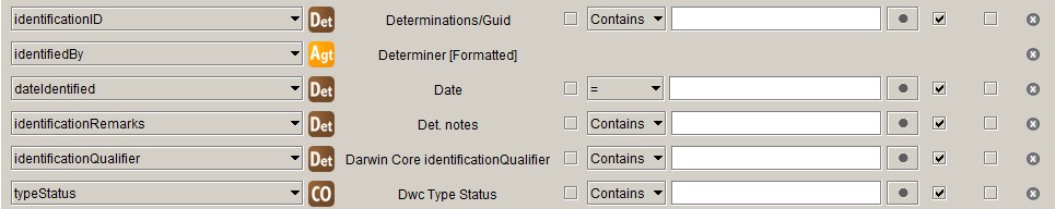
identificationQualifier
Specify has the Qualifier, SubSpQualifier and VarQualifier fields to deal
with uncertain determinations. In our implementation we just use the Qualifier
field and have a pick list field for the rank that the qualifier applies to on
the VarQualifier field.
The Darwin Core identificationQualifier
is a string that contains the qualifier and all parts of the name that come
after it. We use the following function to create the Darwin Core
identificationQualifier string from the data in our database:
DELIMITER $$

/*
* Function creates the Darwin Core identificationQualifier string from elements
* in the Determination and Taxon tables. The DwC identificationQualifier is the
* qualifier plus the part of the scientific name that follows it.
*/
DROP FUNCTION IF EXISTS `dwc_identification_qualifier` $$
CREATE FUNCTION `dwc_identification_qualifier` (in_qualifier VARCHAR(8), in_rank VARCHAR(16), in_taxonID INT)
    RETURNS VARCHAR(255) CHARSET utf8
BEGIN
    DECLARE var_name VARCHAR(255);
    DECLARE var_rank_id INT;

    DECLARE num INT;
    DECLARE ins INT;
    DECLARE spacer VARCHAR(1);

    SELECT t.RankID, t.FullName
    INTO var_rank_id, var_name
    FROM taxon t
    WHERE t.TaxonID=in_taxonID;

    IF in_qualifier IS NULL THEN
        RETURN NULL;
    ELSE
        -- number of name elements
        CASE
            WHEN var_rank_id < 220 THEN SET num = 1; -- genus or monomial
            WHEN var_rank_id = 220 THEN SET num = 2; -- species
            WHEN var_rank_id > 220 THEN SET num = 3; -- infraspecific taxon
        END CASE;

        -- qualifier insertion point
        CASE in_rank
            WHEN 'family' THEN SET ins = 1;     -- preceding name
            WHEN 'genus' THEN SET ins = 1;      --    ,,
            WHEN 'species' THEN SET ins = 2;    -- preceding first epithet
            WHEN 'subspecies' THEN SET ins = 3; -- preceding second epithet
            WHEN 'variety' THEN SET ins = 3;    --    ,,
            WHEN 'forma' THEN SET ins = 3;      --    ,,
            ELSE SET ins = num;
        END CASE;

        -- by default the qualifier is inserted before the last name element
        IF ins > num THEN
            SET ins = num;
        END IF;

        IF in_qualifier='?' THEN
            SET spacer='';
        ELSE
            SET spacer=' ';
        END IF;

        -- return dwc:identificationQualifier
        CASE ins
            WHEN 1 THEN
                RETURN CONCAT(in_qualifier, spacer, CONCAT_WS(' ', split_string(var_name, ' ', 1), split_string(var_name, ' ', 2),
                    split_string(var_name, ' ', 3), split_string(var_name, ' ', 4)));
            WHEN 2 THEN
                RETURN CONCAT(in_qualifier, spacer, CONCAT_WS(' ', split_string(var_name, ' ', 2),
                    split_string(var_name, ' ', 3), split_string(var_name, ' ', 4)));
            WHEN 3 THEN
                RETURN CONCAT(in_qualifier, spacer, CONCAT_WS(' ', split_string(var_name, ' ', 3), split_string(var_name, ' ', 4)));
        END CASE;

    END IF;

END $$
DELIMITER ;
DELIMITER $$

/*
* Function splits the input string (str) on a delimiter (del) and returns the
* bit indicated by the third parameter (i).
* http://stackoverflow.com/questions/14950466/how-to-split-the-name-string-in-mysql#answer-26491403
*/
DROP FUNCTION IF EXISTS `split_string` $$
CREATE FUNCTION `split_string`(str VARCHAR(1024) , del VARCHAR(1) , i INT)
    RETURNS VARCHAR(1024) CHARSET utf8
BEGIN
    DECLARE n INT ;
    SET n = LENGTH(str) - LENGTH(REPLACE(str, del, '')) + 1;
    IF i > n THEN
        RETURN NULL;
    ELSE
        RETURN SUBSTRING_INDEX(SUBSTRING_INDEX(str, del, i) , del , -1 );
    END IF;
END $$

DELIMITER ;
The value that is returned by this function is stored in the Text1 field:
DELIMITER $$

DROP PROCEDURE IF EXISTS update_dwc_identification_qualifier $$
CREATE PROCEDURE update_dwc_identification_qualifier ()
BEGIN
    UPDATE determination
    SET Text1=dwc_identification_qualifier(Qualifier, VarQualifier, TaxonID)
    WHERE Qualifier IS NOT NULL AND TaxonID IS NOT NULL;
END $$

DELIMITER ;
typeStatus
Specify deals with nomenclatural type designations as determinations, so so do
we. We have a determination type – in the FeatureOrBasis field – 'Type
status' to indicate that a determination is really a nomenclatural type status
designation. As, in our implementation, 'Type status' determinations are never
current determinations, they will be excluded from the Darwin Core Occurrence
Core mapping, because in the query underlying the mapping Is Current will be
set to 'Yes'. Also, the Darwin Core typeStatus is different from the Specify
Type Status in that, apart from the type of type, it also contains the
typified name and, optionally, other information. Therefore we store the Darwin
Core typeStatus in a field in the Collection Object table.
The following function compiles the Darwin Core typeStatus string:
DELIMITER $$

/*
* Function checks if a collection object is a type and, if so, concatenates the
* Darwin Core typeStatus string from values of fields in the Determination and
* Taxon tables.
*/
DROP FUNCTION IF EXISTS `dwc_type_status` $$
CREATE FUNCTION `dwc_type_status` (colobjid INT)
RETURNS VARCHAR(1024) CHARSET utf8
BEGIN
    DECLARE var_typeOfType VARCHAR(32);
    DECLARE var_scientificName VARCHAR(128);
    DECLARE var_author VARCHAR(128);
    DECLARE var_protologue VARCHAR(255);
    DECLARE var_year INT;

    DECLARE str VARCHAR(1024);

    SELECT d.TypeStatusName, t.FullName, t.Author, t.CommonName, t.Number2
    INTO var_typeOfType, var_scientificName, var_author, var_protologue, var_year
    FROM determination d
    JOIN taxon t ON d.TaxonID=t.TaxonID
    WHERE d.CollectionObjectID=colobjid AND d.TypeStatusName IS NOT NULL AND d.YesNo1=1
        -- exclude type status designations with qualifiers and authentic specimens
        -- for invalid names
        AND d.SubspQualifier IS NULL AND d.TypeStatusName!='Authentic specimen'
    LIMIT 1;

    IF var_typeOfType IS NULL THEN
        RETURN NULL;
    ELSE
        SET str = CONCAT_WS(' ', var_typeOfType, 'of', var_scientificName, var_author);
        IF var_protologue IS NOT NULL AND var_year IS NOT NULL THEN
            SET str = CONCAT(str, ', ', var_protologue, ' (', var_year, ')');
        END IF;
        RETURN str;
    END IF;

END $$

DELIMITER ;
This procedure stores the returned value in the Description field in the
Collection Object table:
DELIMITER $$

DROP PROCEDURE IF EXISTS update_dwc_type_status $$
CREATE PROCEDURE update_dwc_type_status ()
BEGIN
    UPDATE collectionobject
    SET Description=dwc_type_status(CollectionObjectID)
    WHERE CollectionObjectID IN (
        SELECT CollectionObjectID
        FROM determination
        WHERE TypeStatusName IS NOT NULL
            AND YesNo1=1 AND SubspQualifier IS NULL AND TypeStatusName!='Authentic specimen'
    );

    UPDATE collectionobject
    SET Description=NULL
    WHERE CollectionObjectID NOT IN (
        SELECT CollectionObjectID
        FROM determination
        WHERE TypeStatusName IS NOT NULL
            AND YesNo1=1 AND SubspQualifier IS NULL AND TypeStatusName!='Authentic specimen'
    );
END $$

DELIMITER ;
Taxon
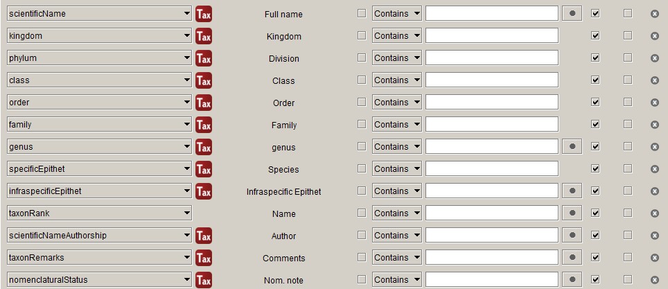
infraspecificEpithet
Because we are a herbarium we have to deal with multiple infraspecific ranks. The Specify query provides subspecies, variety etc., but not a single infraspecific epithet. So we have to store it somewhere ourselves.
We have been doing this for years with a trigger, which I will not show, as the use of triggers is frowned upon by the Specify Collections Consortium, but it does something like this:
UPDATE taxon SET Text5="Name" WHERE RankID>220;
Post-processing
The following query is used for the Occurrence Core in the IPT:
SELECT
  m.occurrenceID,

  -- Record Level Terms
  'PhysicalObject' AS `type`,
  modified,
  'https://creativecommons.org/licenses/by/4.0/legalcode' AS license,
  'Royal Botanic Gardens Board' AS rightsHolder,
  m.institutionCode,
  m.collectionCode,
  'PreservedSpecimen' AS basisOfRecord,

  -- Occurrence
  m.catalogNumber,
  m.occurrenceRemarks,
  m.recordNumber,
  replace(m.recordedBy, '; ', '|') AS recordedBy,
  ai.recordedByID,
  m.reproductiveCondition,
  m.establishmentMeans,
  'present' AS occurrenceStatus,
  replace(m.preparations, '; ', '|') AS preparations,
  replace(m.associatedSequences, ' | ', '|') AS associatedSequences,
  -- associatedTaxa,

  -- Organism
  -- previousIdentifications,

  -- Event
  m.eventID,
  m.parentEventID,
  CONCAT_WS('/', ipt_iso_date(m.eventDateStart)/ipt_iso_date(m.eventDateEnd)) AS eventDate,
  IF(m.eventDateEnd IS NULL, ipt_startDayOfYear(m.eventDateStart), NULL) AS startDayOfYear,
  m.`year`,
  m.`month`,
  m.`day`,
  m.verbatimEventDate,
  m.habitat,

  -- Location
  m.locationID,
  m.waterBody,
  m.islandGroup,
  m.island,
  m.country,
  m.countryCode,
  m.stateProvince,
  m.county,
  m.verbatimLocality AS locality,
  m.verbatimLocality,
  m.verbatimElevation,
  m.minimumElevationInMeters,
  m.maximumElevationInMeters,
  m.verbatimDepth,
  m.minimumDepthInMeters,
  m.maximumDepthInMeters,
  IF(m.decimalLatitude IS NOT NULL, m.verbatimLatitude, NULL) AS verbatimLatitude,
  IF(m.verbatimLongitude IS NOT NULL, m.verbatimLongitude, NULL) AS verbatimLongitude,
  m.verbatimCoordinateSystem,
  srs_from_datum(m.geodeticDatum) AS verbatimSRS,
  m.decimalLatitude,
  m.decimalLongitude,
  srs_from_datum(m.geodeticDatum) AS geodeticDatum,
  m.coordinateUncertaintyInMeters,
  ROUND(m.coordinatePrecision, 7) AS coordinatePrecision,
  m.georeferencedBy,
  m.georeferencedDate,
  m.georeferenceProtocol,
  m.georeferenceSources,
  m.georeferenceVerificationStatus,
  m.georeferenceRemarks,

  -- Identification
  m.identificationID,
  replace(m.identifiedBy, '; ', '|') AS identifiedBy,
  ai.identifiedByID,
  m.dateIdentified,
  m.identificationRemarks,
  m.identificationQualifier,
  m.typeStatus,

  -- Taxon
  m.scientificName,
  m.kingdom,
  m.phylum,
  m.class,
  m.`order`,
  m.family,
  m.genus,
  m.specificEpithet,
  m.taxonRank,
  m.scientificNameAuthorship,
  m.taxonRemarks,
  'ICN' AS nomenclaturalCode,
  m.nomenclaturalStatus

FROM mel_avh_occurrence_core m
JOIN mel_avh_occurrence_core_agent_id ai ON m.mel_avh_occurrence_coreId=ai.CollectionObjectID
Default values
Many terms have the same value for every record in the data set. Currently, the
ALA ingestion pipeline does not honour the defaults set in the meta.xml file
of the Darwin Core Archive. You can set default values elsewhere, but I prefer
to have everything in the data.
Aggregated terms
We prefer to use a semicolon as the separator in aggregated values, but Darwin Core recommends pipes, so I replace the semicolons with pipes.
Incomplete dates
The Specify Data Exporter leaves in the '-00' for incomplete dates, which makes them invalid ISO dates and makes the IPT throw a tantrum. The following function strips the '-00' of incomplete dates:
DELIMITER $$

DROP FUNCTION IF EXISTS `ipt_iso_date` $$
CREATE FUNCTION `ipt_iso_date`(in_date varchar(16)) RETURNS varchar(16) CHARSET utf8
BEGIN
  RETURN replace(in_date, '-00', '');
END $$

DELIMITER ;
eventDate
We concatenate eventDateStart and eventDateEnd with
CONCAT_WS('/', ipt_iso_date(m.eventDateStart, m.eventDateEnd).
startDayOfYear
I am not sure how useful startDayOfYear is, but I can imagine a use for it in
phenology studies and it is calculated easily enough from the eventDate.
DROP function IF EXISTS `ipt_startDayOfYear`;

DELIMITER $$
CREATE FUNCTION `ipt_startDayOfYear`(in_date varchar(16))
RETURNS int(11)
BEGIN
	DECLARE var_iso_date varchar(16);
    SET var_iso_date=ipt_iso_date(in_date);
    IF LENGTH(var_iso_date)=10 THEN
        RETURN DAYOFYEAR(var_iso_date);
	ELSE
        RETURN NULL;
    END IF;
END$$

DELIMITER ;
verbatimLatitude, verbatimLongitude
Specify often puts '0° S' in Lat1Text when there is no latitude and
longitude, which is harmless, but does not look so good if it ends up in a data
set, so we only deliver a value for verbatimLatitude and verbatimLongitude
if we also have decimalLatitude and decimalLongitude.
verbatimSRS, geodeticDatum
We have datums in our database, but Darwin Core recommends Spatial Reference System (SRS). You could map the values in the IPT, but then you would have to verify that the mapping is still there every time you change something in the IPT and, moreover, you would have to do it twice. So I do it in the query.
DROP function IF EXISTS `srs_from_datum`;

DELIMITER $$
USE `melisr`$$
CREATE FUNCTION `srs_from_datum`(in_datum varchar(16)) RETURNS varchar(16) CHARSET utf8
BEGIN
    DECLARE out_srs VARCHAR(16);
    SET out_srs = CASE in_datum
      WHEN 'WGS84' THEN 'epsg:4326'
      WHEN 'GDA94' THEN 'epsg:4283'
      WHEN 'AGD84' THEN 'epsg:4203'
      WHEN 'AGD66' THEN 'epsg:4202'
      WHEN 'Minna' THEN 'epsg:4263'
      ELSE null
	END;
RETURN 1;
END$$

DELIMITER ;
coordinatePrecision
While Latitude1 and Longitude1 are stored with ten decimal places, the
exported values only have seven. Therefore, we round the values of
coordinatePrecision to seven decimal places as well in order to try and pass
the 'Coordinate precision not valid' test in ALA.
recordedByID, identifiedByID
I will explain later.